Mount Tom White
| Mount Tom White | ||
|---|---|---|
|
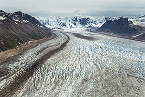
Mount Tom White from the north; in the foreground the Fan Glacier |
||
| height | 3411 m | |
| location | Alaska (USA) | |
| Mountains | Chugach Mountains | |
| Dominance | 115.8 km → Mount Blackburn (The Snave) | |
| Notch height | 2314 m ↓ (1097 m) | |
| Coordinates | 60 ° 39 '6 " N , 143 ° 41' 50" W | |
| Topo map | USGS Bering Glacier C-8 | |
|
|
||
| First ascent | Jun 29, 1973 by William Resor, Story Clark, Sarah Robey, Don White, Chris Hall, Tom Kizzia | |
The Mount Tom White is a 3411 m high mountain in the eastern Chugach Mountains in Alaska .
The mountain lies on the border between Wrangell-St.-Elias National Park in the north and Chugach National Forest in the south. The lower valley of the Copper River is 50 km to the west. The Fan Glacier stretches on the northern flank of Mount Tom White , while the Martin River Glacier flows westward along the southern flank . The western flank of the mountain is drained via the Miles Glacier .
The first ascent was made by a group of 6 on June 29, 1973. They reached the summit from the west over the Miles Glacier.
The mountain was named after Tom White, an early pioneer in Southeast Alaska.
Web links
- Mount Tom White in the Geographic Names Information System of the United States Geological Survey
- Mount Tom White, Alaska on Peakbagger.com (English)
Individual evidence
- ^ A b William Resor: North America, United States, Alaska, Mount Tom White, Chugach Mountains . American Alpine Journal. 1974. Retrieved December 26, 2017.
- ↑ Mount Tom White in the Geographic Names Information System of the United States Geological Survey

