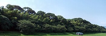
Mizuki (fortress)
The Mizuki ( Japanese 水城 , German "water fortress") is a wall and a fortification that Japan built in the middle of the 7th century to protect against invasion and to secure borders. The associated wall extended from today's city of Ōnojō , Fukuoka prefecture to Dazaifu . The remains of the Mizuki were declared with 150,805 m² on March 3, 1921 as a historic site and on March 31, 1953 as a special historic site .
Historical background
The Tang Dynasty of China, which replaced the Sui Dynasty in 618 , resumed the attacks in 645 which the previous dynasty had unsuccessfully waged against the (Korean) Goguryeo . In addition, Silla allied with the Tang dynasty against Baekje . Japan had annoyed the Chinese emperor by writing a letter from the "ruler of the sunrise" to the "ruler of the sunset". Although Japan sent several embassies to the Tang Court, Tang did not succeed in appeasing Tang. When the united advance of Tang and Silla against Baekje was successful in 660 and Baekje, an ally of Japan, fell, the ruler of Baekje was granted asylum near Osaka. In an alliance with Japan in 663 a fleet of 400 ships was dispatched to retake Baekje. This military intervention turned into a major failure for Japan due to a misjudgment by the fleet commander in the Battle of Hakusukinoe ( 白 村 江 の 戦 い ). The loss of the Japanese fleet and the unsuccessful military advance heightened fears in Japan of an impending invasion by Tang China.
Tennō Tenji thought it very likely that such an invading army would land somewhere near Hakata Bay . For this reason, in 664 he ordered the construction of a defensive wall, the Mizuki, for the Dazaifu regional center behind it . First a 14 m high and one kilometer long wall was built on the Fukuoka plain. A year later, the wall from today's Kitakyūshū to the banks of the Seto Inland Sea was extended by smaller fortifications based on the Korean model ( 朝鮮 式 山城 ): Ōno-jō ( 大野 城 ; 33 ° 32 ′ 23.7 ″ N , 130 ° 31 ′ 17.6 " O ) of hill Ōnoyama, Kii-yo ( 基肄城 ; 33 ° 26 '41.3" N , 130 ° 30' 47.8 " O ) in the Kiyama and Nagato-no-ki ( 長門城 ) in Nagato Province. The fortifications were placed under the command of Okurai Fukuru ( 憶 礼 福 留 , kor .: Eokrye Bokryu) and Shihi Fukufu ( 四 比福夫 , kor .: Sacha Bokbu), both of whom had fled to Japan from Baekje. Despite the efforts of Japan, however, 47 ships with 2,000 emissaries from the Tang Dynasty appeared in Japan in 664, who subsequently stayed at the Japanese court for several years.
The erected facilities were renewed and repaired as a line of defense on the occasion of the Mongol invasion of Japan in 1274.
Construction method and purpose

The Mizuki consisted of a trench and an earth wall, which ran in a straight line as a line of defense to protect Dazaifu from attacks from the direction of Hakata Bay. The earth wall was approx. 10 m high, 80 m wide and extended over a length of 1.2 km. At Hakata Bay, the earth wall was also provided with a moat that was 60 m wide and four meters deep. The water was introduced into the trench from the Mikasa River ( 御 笠 川 ).
There is also the opinion that the trench was dry per se and that the water of the Mikasa was dammed up in order to channel it into the trench in the event of an attack and drown oncoming enemies. The hardship of damming the water and the existence of wooden water pipes make this explanation seem rather unlikely.
Individual evidence
- ↑ 水城 . In: デ ジ タ ル 版 日本人 名 大 辞典 + Plus at kotobank.jp. Retrieved September 12, 2013 (Japanese).
- ↑ 水城 跡 . In: 国 指定 文化 財 等 デ ー タ ベ ー ス (cultural monuments database). Bunka-chō , accessed October 19, 2013 (Japanese).
- ↑ a b c Josef Kreiner: Prehistoric and early historical foundations . In: Josef Kreiner (ed.): Small history of Japan (= Reclam ). Phillipp Reclam Stuttgart, Stuttgart 2010, ISBN 978-3-15-010783-6 , pp. 47-50 .
- ↑ 憶 礼 福 留 . In: デ ジ タ ル 版 日本人 名 大 辞典 + Plus at kotobank.jp. Retrieved September 12, 2013 (Japanese).
- ↑ 大野 城 . 太宰府 市 文化 ふ れ あ い 館 , archived from the original on May 25, 2013 ; Retrieved September 12, 2013 (Japanese).
Coordinates: 33 ° 31 ′ 5.2 " N , 130 ° 29 ′ 34.1" E

