Ōnojō
| Ōnojō-shi 大野 城市 |
||
|---|---|---|
|
|
||
| Geographical location in Japan | ||
| Region : | Kyushu | |
| Prefecture : | Fukuoka | |
| Coordinates : | 33 ° 32 ' N , 130 ° 29' E | |
| Basic data | ||
| Surface: | 26.88 km² | |
| Residents : | 101,017 (October 1, 2019) |
|
| Population density : | 3758 inhabitants per km² | |
| Community key : | 40219-2 | |
| Symbols | ||
| Flag / coat of arms: | ||
| Tree : | Ilex rotunda | |
| Flower : | Balloon flower | |
| town hall | ||
| Address : |
Ōnojō City Hall 2 - 2 - 1 , Akebono-machi Ōnojō -shi Fukuoka 816-8510 |
|
| Website URL: | http://www.city.onojo.fukuoka.jp | |
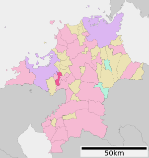
| Location of Onojos in Fukuoka Prefecture | ||
Ōnojō ( Japanese 大野 城市 , - shi ) is a city in Japan in Fukuoka Prefecture . It is a southern suburb of Fukuoka .
history
The city was officially founded on April 1, 1972 .
traffic
There is a JR station in town , 5 stops south of Hakata Station on the Kagoshima Main Line . The Nishitetsu with its Tenjin-Omuta line also serves the area.
- Streets:
- Railroad:
sons and daughters of the town
- ASKA (* 1958), J-Pop singer
- Shintarō Ikeda (* 1980), Japanese badminton player
- Toshiya Sugiuchi (* 1980), baseball player
Neighboring cities and communities
Ōnojō borders in the northwest on the municipality of Hakata-ku of the city of Fukuoka, as well as on the cities and towns of Dazaifu , Kasuga , Umi , Chikushino , Nakagawa and Shime .
Web links
Commons : Ōnojō - collection of images, videos and audio files


