
Sasaguri (Fukuoka)
| Sasaguri-machi 篠 栗 町 |
|||
|---|---|---|---|
|
|||
| Geographical location in Japan | |||
| Region : | Kyushu | ||
| Prefecture : | Fukuoka | ||
| Coordinates : | 33 ° 37 ' N , 130 ° 32' E | ||
| Basic data | |||
| Surface: | 38.90 km² | ||
| Residents : | 30,886 (October 1, 2019) |
||
| Population density : | 794 inhabitants per km² | ||
| Community key : | 40342-3 | ||
| Symbols | |||
| Flag / coat of arms: |
 |
||
| Tree : | Crescent fir | ||
| Flower : | orchid | ||
| Bird : | Oriental turtle dove | ||
| town hall | |||
| Address : |
Sasaguri Town Hall 4855 - 5 , Oaza Sasaguri Sasaguri -machi, Kasuya-gun Fukuoka 811-2492 |
||
| Website URL: | http://www.town.sasaguri.fukuoka.jp | ||

Sasaguri ( Japanese 篠 栗 町 ; - machi ) is a community in Kasuya County in Fukuoka Prefecture , Japan .
The city of Sasaguri has 31,213 inhabitants (as of October 1, 2016). The area is 38.90 km² and the population density is about 802 people per km².
Sasaguri pilgrimage route
Based on the famous Shikoku pilgrimage route, there are the “88 places of Shikoku in Sasaguri” ( Japanese 篠 栗 四 国 八 十八 箇 所 , Sasaguri Shikoku hachijū hakkasho ), a “miniature pilgrimage” to the worship of Kūkai (774–835 ), the founder of the Shingon Buddhist school .

Fudō myō-ō ( Acala ) in the Hirahara Kannon-dō Temple (Station No. 41)
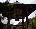
Akashi Temple Bell Tower (Station # 43)
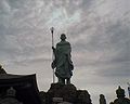
Statue of Kūkai in the Henshō-in Temple (Station No. 62)
Yakushi-dō, a temple dedicated to the Buddha of Healing ( Bhaisajyaguru ) (Station No. 74)
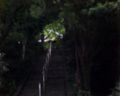
Ascent to the Yamate Amida-do Temple (Station No. 78)


Neighboring cities and communities
Web links
- Official website in Japanese
Independent cities ( shi ): Asakura | Buzen | Chikugo | Chikushino | Dazaifu | Fukuoka (administrative headquarters) | Fukutsu | Iizuka | Itoshima | Kama | Kasuga | Kitakyushu | Koga | Kurume | Miyama | Miyawaka | Munakata | Nakagawa | Nakama | Nogata | Ogōri | Ōkawa | Ōmuta | Ōnojō | Tagawa | Ukiha | Yame | Yanagawa | Yukuhashi
Asakura-gun : Chikuzen | Tōhō | Chikujō-gun : Chikujō | Kōge | Yoshitomi | Kaho-gun : Keisen | Kasuya-gun : Hisayama | Kasuya | Sasaguri | Shime | Shingū | Sue | Umi | Curate-gun : Kotake | Curates | Mii-gun : Tachiarai | Miyako-gun : Kanda | Miyako | Mizuma-gun : Ōki | Onga-gun : Ashiya | Mizumaki | Okagaki | Onga | Tagawa-gun : Aka | Fukuchi | Itoda | Kawara | Kawasaki | Ōtō | Soeda | Yame-gun : Hirokawa