Kama (Fukuoka)
| Kama-shi 嘉 麻 市 |
||
|---|---|---|
|
|
||
| Geographical location in Japan | ||
| Region : | Kyushu | |
| Prefecture : | Fukuoka | |
| Coordinates : | 33 ° 34 ' N , 130 ° 43' E | |
| Basic data | ||
| Surface: | 135.18 km² | |
| Residents : | 35,929 (October 1, 2019) |
|
| Population density : | 266 inhabitants per km² | |
| Community key : | 40227-3 | |
| Symbols | ||
| Flag / coat of arms: | ||
| town hall | ||
| Address : |
Kama City Hall 446 - 1 , Kami-Usui Kama shi Fukuoka 820-0502 |
|
| Website URL: | http://www.city.kama.lg.jp | |
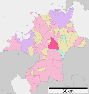
| Location Kamas in Fukuoka Prefecture | ||
Kama ( Japanese 嘉 麻 市 , -shi ) is a city in Fukuoka Prefecture , Japan .
geography
Kama is south of Kitakyushu and east of Fukuoka .
history
The city of Kama was created on March 27, 2006 through the merger of the city of Yamada ( 山田 市 , -shi ) with the communities of Usui ( 碓 井 町 , -machi ), Inatsuki ( 稲 築 町 , -machi ) and Kaho ( 嘉 穂 町 , -machi ) of Kaho County .
traffic
- Streets:
- National roads 211,322
- Railroad:
sons and daughters of the town
Neighboring cities and communities
Web links
Commons : Kama - collection of images, videos and audio files


