Yanagawa
| Yanagawa-shi 柳川 市 |
||
|---|---|---|
| Geographical location in Japan | ||
|
|
||
| Region : | Kyushu | |
| Prefecture : | Fukuoka | |
| Coordinates : | 33 ° 10 ' N , 130 ° 24' E | |
| Basic data | ||
| Surface: | 76.88 km² | |
| Residents : | 64,705 (October 1, 2019) |
|
| Population density : | 842 inhabitants per km² | |
| Community key : | 44207-9 | |
| Symbols | ||
| Flag / coat of arms: | ||
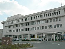
| town hall | ||
| Address : |
Yanagawa City Hall 87 - 1 , Hon-machi Yanagawa -shi Fukuoka 832-8601 |
|
| Website URL: | http://www.city.yanagawa.fukuoka.jp | |
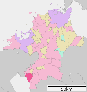
| Location of Yanagawa's in Fukuoka Prefecture | ||
Yanagawa ( Japanese 柳川 市 , - shi ) is a city in Fukuoka Prefecture in Japan .
geography
Yanagawa is south of Fukuoka and Kurume , and north of Kumamoto .
history
Yanagawa is an ancient castle town that was ruled by the Tachibana with an income of 110,000 koku during the Edo period . Located in the triangle between the Chikugo River and the Yatabe River and crisscrossed by many canals, the city is still a "Little Venice" today, in which many "gondoliers" are ready to take guests through the city. The place received on April 1, 1952 the status of a city (shi).
traffic
- Streets:
- National roads 208, 385, 443
sons and daughters of the town
- Unryū Kyūkichi , sumo wrestler
- Kotoshōgiku Kazuhiro (* 1984), sumo wrestler
- Satoshi Tsumabuki , actor
- Hideaki Tokunaga , J-Pop singer
- Hakushū Kitahara (1885–1942), poet
Neighboring cities and communities
Web links
Commons : Yanagawa - collection of pictures, videos and audio files


