Mohave Valley (CDP)
| Mohave Valley | |
|---|---|
|
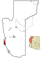
Location in County and Arizona
|
|
| Basic data | |
| State : | United States |
| State : | Arizona |
| County : | Mohave County |
| Coordinates : | 34 ° 57 ′ N , 114 ° 35 ′ W |
| Time zone : | Mountain Standard Time ( UTC − 7 ) |
| Residents : | 13,694 (as of: 2000) |
| Population density : | 116.8 inhabitants per km 2 |
| Area : | 117.3 km 2 (approx. 45 mi 2 ) of which 117.2 km 2 (approx. 45 mi 2 ) is land |
| Height : | 159 m |
| Postcodes : | 86440, 86446 |
| Area code : | +1 928 |
| FIPS : | 04-47400 |
| GNIS ID : | 1866989 |
Mohave Valley is a census-designated place (CDP) in Mohave County in the US state of Arizona . It has 13,694 inhabitants on an area of 117.6 km². The population density is thus 116.8 / km².
The CDP is located directly on the Colorado River . To the south of the area are Topock Marsh Lake , Beal Lake, and Topock Bay . Mohave Valley is entirely within the Fort Mohave Indian Reservation . At the north end of the CSP is the ghost town of Fort Mohave .
Arizona State Route 95 runs through Mohave Valley .
Web links
Commons : Mohave Valley, Arizona - Collection of images, videos, and audio files
