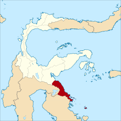
Morowali (administrative district)
| Kabupaten Morowali Morowali Governorate
|
|
|---|---|
 |
|
| Basic data | |
| Country | Indonesia |
| province | Sulawesi Tengah |
| Seat | Bungku |
| surface | 15,490.1 km² |
| Residents | 206,189 (2010) |
| density | 13 inhabitants per km² |
| ISO 3166-2 | ID-ST |
| politics | |
| Bupati | Anwar Hafid |
Coordinates: 1 ° 51 ′ S , 121 ° 18 ′ E
Morowali is a government district ( Kabupaten ) on the Indonesian island of Sulawesi . The district is part of the Sulawesi Tengah Province ( Central Sulawesi ). 206,189 inhabitants live here (2010).
geography
Morowali has an area of 15,490.12 km². The capital is Bungku .
Administrative division
The Morowali district consists of 14 administrative districts ( Kecamatan ) and 238 villages (Desa) (as of 2010):
| District | Population census 2010 |
|---|---|
|
Menui Kepulauan (Menui Islands) |
12,064 |
| Bungku Pesisir | (Separated from Südbungku in 2011) |
|
South Bungku (Bungku Selatan) |
17,273 |
| Bahodopi | 6,594 |
|
Central Bungku (Bungku Tengah) |
27,774 |
|
West Bungku (Bungku Barat) |
10.093 |
|
East Bungku (Bungku Timur) |
(Separated from Zentralbungku in 2011) |
| Bumi Raya | 11,488 |
| Wita Pondo | 16,942 |
| Lembo | 20,300 (delivered to North Morowali in 2013) |
| Mori Atas | 10,418 (delivered to North Moravali in 2013) |
|
North Mori (Mori Utara) |
6,819 |
| Petasia | 33,705 (delivered to North Moravali in 2013) |
| Soyo Jaya | 7,884 (delivered to North Moravali in 2013) |
|
North Bungku (Bungku Utara) |
14,699 |
| Mamosalato | 10,269 (delivered to North Moravali in 2013) |
Individual evidence
- ^ Biro Pusat Statistics, Jakarta, 2011.
