Morrumbala (District)
| Morrumbala District | |
|---|---|
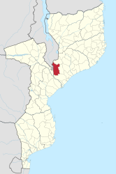
 Location of the Morrumbala district in Mozambique |
|
| Basic data | |
| Country | Mozambique |
| province | Zambezia |
| surface | 12,801 km² |
| Residents | 422,309 (2013) |
| density | 33 inhabitants per km² |
| ISO 3166-2 | MZ-Q |
Coordinates: 17 ° 20 ′ S , 35 ° 35 ′ E
Morrumbala is a Mozambican district in the province of Zambezia , its capital is Morrumbala . The district is located in the west of the province, it borders in the north with the district Milange , in the west with the province Tete and the Republic of Malawi , in the south with the district Mopeia and in the east with the districts Nicoadala and Mocuba .
geography
The district has an area of 12,801 square kilometers and 422,801 inhabitants (as of 2013). The majority of the district extends on the Morrumbala plateau, which is about 400 meters above sea level. The highest point in the southwest is the mountain Morrumbala with a height of 1,172 meters. The plateau slopes steeply to the west to the valley of the River Shire . This is the outflow of Lake Malawi in Malawi and flows south of Morrumbala into the Zambezi .
According to the Köppen-Geiger classification, the climate is a tropical savannah climate (Aw). The annual average temperature is 23.4 degrees. The average rainfall is 1,017 millimeters, with the majority falling in the winter months from November to March.
population
The population density in the Morrumbala district is 33 people per square kilometer.
|
 |
Facilities and services
| There are 334 primary schools ( Primárias) and eight secondary schools (Secundárias) in the district. Of the primary schools, 237 are public schools and 97 are private schools, and the secondary schools are all private schools.
In Morrumbala there are thirteen health centers and three outpatient departments (as of 2013). In 2007, 9.2 percent of the population over 10 years of age had attended primary school and 1.4 percent had attended secondary school. 0.1 percent had a higher degree, over 89 percent had no school education. |
 |
Administrative division
The Morrumbala district is divided into four administrative posts ( postos administrativos ):
Economy and Infrastructure
In 2007, 1.1 percent of the population had access to electrical energy. Two thirds of the residents got their drinking water from a well , only a few had access to a spring or tap water . Over thirty percent of their water came from flowing or standing water.
78.2 percent of the population over 15 years of age were employed; 79.2 percent of men and 77.2 percent of women.
Agriculture
More than a third of the farms were under one hectare in size, and almost forty percent farmed an area of one to two hectares. Less than 2 percent of the farms were larger than five hectares and there was no farm with more than twenty hectares of land (as of 2010). Most of the acreage was for corn (75,000 hectares), cassava (39,000 hectares) and millet (24,000 hectares). The highest yields were found in cassava (169,000 tons), corn (130,000 tons) and sweet potatoes (39,000 tons).
Natural resources
The few natural resources that are mined in Morrumbala are sand for building purposes, as well as limestone and corundum .
traffic
The district has a road network of 650 kilometers, the national road EN1 leads just south of Morrumbala. There is no railroad in the district.


