Mosha
|
Moscha Моша |
||
|
|
||
| Data | ||
| Water code | RU : 03010000112103000001977 | |
| location | Arkhangelsk Oblast ( Russia ) | |
| River system | Onega | |
| Drain over | Onega → White Sea | |
| origin |
Bolshoye Moschenskoye Lake 61 ° 47 ′ 10 ″ N , 40 ° 16 ′ 29 ″ E |
|
| muzzle | 45 km southwest of Plesetsk in the Onega
|
|
| length | 131 km (with source rivers Jemenga and Wojeserka: 179 km) | |
| Catchment area | 8450 km² | |
| Discharge at the Myschelowo A Eo gauge : 8110 km² Location: 12 km above the mouth |
MQ 1932/1981 Mq 1932/1981 |
65 m³ / s 8 l / (s km²) |
| Left tributaries | Iksa , Schoschma , Lelma | |
| Right tributaries | Lim , Lepsha | |
|
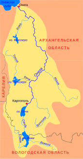
Location of the Mosha (Моша) in the catchment area of the Onega |
||
The Mosha ( Russian Моша ) is a right tributary of the Onega in the Arkhangelsk Oblast in northwestern Russia .
The Mosha forms the outflow of the Bolshoye Moschenskoye Lake . The Mosha flows through the administrative districts of Nyandoma and Plesezk in a north-westerly direction. It takes in the tributaries of the Iksa (left), Lim (right), Shoschma (left), Lepscha (right) and Lelma (left). They finally flows 45 km southwest of Plesetsk in the Onega .
The Mosha has a length of 131 km. It drains an area of 8450 km². The mean discharge 12 km above the mouth is 65 m³ / s. The Mosha floods in May .
Individual evidence
- ↑ a b Moscha in the State Water Directory of the Russian Federation (Russian)
- ↑ a b c Moscha at the Myschelowo gauge - hydrographic data at R-ArcticNET
