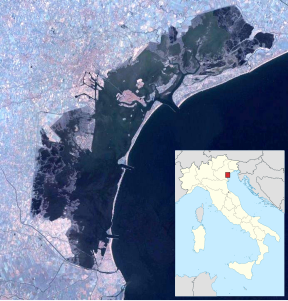
Motta dei Cunicci
| Motta dei Cunicci | ||
|---|---|---|
| Waters | Venice lagoon | |
| Geographical location | 45 ° 30 '47.3 " N , 12 ° 27' 19.8" E | |
|
|
||
| surface | 0.454 7 ha | |
In Motta dei Cunicci is a small island in the northern lagoon of Venice , whose name part, cunicci 'to rabbits' back. It has an area of 4,547 m² or just over 0.45 hectares and is located east of Torcello .
history
The island is not a remnant of the Ammiana known from early medieval sources , to which the islands of La Salina (formerly Motta di San Felice) and Santa Cristina belonged, but a remnant of Ammianella. This was connected to Ammiana by bridges, which can still be seen today under the water's surface. The city and the island, also settled in Roman times (finds more than 2.5 m below sea level), fell in the 14th / 15th centuries. Century victim to the rising water level of the lagoon, the silting up by the deposits of the river Sile and malaria .
The local monastery of S. Andrea was a successor to the monastery of S. Felice di Ducia. There led in the 11./12. Century, possibly earlier, processions in honor of Saints Marcellian and Eliodoro. The homines de Venecia drove in barges to the remote church of S. Felice di Doza. A document dated September 4, 1313, in which there is a dispute between S. Felice di Ammiana and Raynerio Venier, more precisely about the border in the area of the “Ducia”, says: “l'isola di S. Andrea dove sone le tombe della chiesa di S. Felice in Ducia ”. Structural continuity was therefore considered proven. Aerial photos provided further confirmation of the existence of the said structures and graves in the east, but especially in the water off the island. Archaeological investigations also uncovered Roman artifacts at a depth of −2.5 m, including remains of walls, glass and amphorae, bronze and lead objects, terra sigillata aretina and, from northern Italy, then worked marble and remains of mosaics. 6 m from the island were the remains of an early medieval well or a cistern, then the "Basilica di S. Felice in Ducia" mentioned in the sources, the basilica belonging to the monastery. Structural structures were found not only south of today's island, but also north, including road sections 230 and 100 m in length.
At the end of the 12th century, the name Ammianella was replaced by the two saints' names Andrea and Giacomo. The local convent was consecrated to these saints, which from 1179 onwards became the Canon Regulars of St. Augustine was under. Until 1230 they were not allowed to own any property outside of the diocese of Torcello , which in 1230 Pope Gregory IX changed on the grounds that the monks had grown so numerous and that they were home to so many poor and pilgrims.
In 1436, however, the bishop of Olivolo, Lorenzo Giustiniani , combined the few remaining returns from the now empty monastery with those from the nunnery of S. Girolamo in Venice. A few years later, Ammianella, or S. Andrea, was completely abandoned, the buildings there were in ruins. In modern times, the name Motta dei Cunicci prevailed. Today you can only see the remains of a flat island in the extensive Palude Fondazzo, which is almost completely flooded when the tides are high.
literature
- Ernesto Canal : Archeologia della laguna di Venezia , Venice 2015, pp. 357-363 ( Sito 144. Isola di S. Andrea e di S. Felice in Ducia ).
Web links
- Motta dei Cunicci, website of the Comune di Venezia ( memento of September 18, 2009 in the Internet Archive ), September 18, 2009
- Photography of the island
Remarks
- ^ Giorgio and Maurizio Crovato: Isole abbandonate della laguna com'erano e come sono , San Marco Press, 2008, p. 12.
- ↑ Venice Islands ( memento of March 24, 2009 in the Internet Archive ).
- ↑ Pactum Lotharii , MGH, Capitularia regum Francorum, ed. A. Boretius, Vol. 2, Hanover, 1883-1897, II, n. 223, February 23, 840. There “Amianae” and “Buriani”, the latter inhabitants of the island of Burano , are mentioned.
- ^ Ernesto Canal : Archeologia della laguna di Venezia , Venice 2015, p. 358.
