Mount Kaputar
| Mount Kaputar | ||
|---|---|---|
|
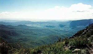
View from Mount Kaputar in west direction |
||
| height | 1508 m | |
| location | New South Wales , Australia | |
| Mountains | Nandewar Range | |
| Coordinates | 30 ° 12 '53 " S , 150 ° 8' 43" O | |
|
|
||
| rock | Volcanic rock | |
| Age of the rock | 17 million years | |
| Last eruption | 17 to 18 million years | |
The Mount Kaputar is a 1,508 m high mountain near Narrabri in northern New South Wales . It is part of the Nandewar Range in Mount Kaputar National Park . The volcanic mountain is a noticeable landmark for travelers on the Newell Highway as it rises abruptly. In cold winters it can be easily covered with snow.
The mountain top can be reached from Narrabri on a 57 km long, winding and narrow road that is only partially paved. Various telecommunications and television systems are located on the neighboring Mount Dowe , which also rises over 1,500 m. The large antenna system can be seen from the Kamilaroi Highway southwards from the Gunnedah Basin .
At the top of Mount Kaputar there is a lookout point, Mount Kaputar Lookout . Nearby are the Governor Lookout and Eckfords Lookout as well as Dawson Spring with cabins, picnic areas and camping facilities.
The Mount Kaputar is the relic of an extinct volcano, which was active before 18 million years ago. The Mount Lindesay was probably the center of this volcanic field. The mountain is forested with dry hard foliage vegetation .
Web links
- volcanolive.com : Pictures of the mountain
- ozforecast.com.au : Weather station on Mount Kapitar with webcam
Individual evidence
- ↑ Geoffrey Hutton: Australia's natural heritage. New edition. Collins et al., Sydney et al. 1983, ISBN 0-00-217297-6 , p. 102.
- ↑ a b c Mount Kapural National Park park guide. [Brochure] New South Wales National Parks and Wildlife Service. June 1994.


