Mount Nicholas
| Mount Nicholas | ||
|---|---|---|
|
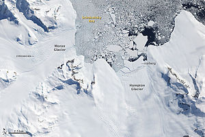
Satellite image from 2009 of the northern end of the Douglas Range with Mount Nicholas (right) east of the Hampton Glacier |
||
| height | 1465 m | |
| location | Alexander I Island , Antarctica | |
| Mountains | Douglas Range | |
| Coordinates | 69 ° 21 '56 " S , 69 ° 51' 10" W | |
|
|
||
| Normal way | Alpine tour (glaciated) | |
Mount Nicholas is a 1465 m (according to the UK Antarctic Place-Names Committee 1350 m ) high mountain in the northeast of the West Antarctic Alexander I Island . It rises 9 km south-southwest of Cape Brown and forms the northern extension of the Douglas Range .
It was first sighted and roughly mapped in 1909 during the Fifth French Antarctic Expedition (1908–1910) under the direction of Jean-Baptiste Charcot , who mistakenly assumed the mountain was an island as Ile Nicolas II after the Russian Tsar Nicholas II. (1868-1918) named. After the evaluation of aerial photographs taken in 1937 during the British Graham Land Expedition (1934–1937) under the direction of the Australian polar explorer John Rymill , the name was also mistakenly changed to Cape Nicholas , and this for an extension of the 42 km further north-northwest Mount Calais . It was not until 1948 that the Falkland Islands Dependencies Survey carried out surveying work that the island, originally named by Charcot, was identified as a mountain.
Web links
- Mount Nicholas in the Geographic Names Information System of the United States Geological Survey (English)
- Mount Nicholas on geographic.org (English)

