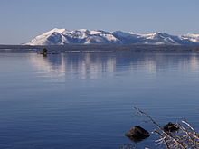
Mount Sheridan
| Mount Sheridan | ||
|---|---|---|
|
Mount Sheridan and Heart Lake |
||
| height | 3139 m | |
| location | USA , Wyoming , Teton County | |
| Mountains | Red Mountains | |
| Coordinates | 44 ° 15 '58 " N , 110 ° 31' 46" W | |
|
|
||
| Normal way | Mount Sheridan Trail | |
The Mount Sheridan is a mountain in the Red Mountains of Yellowstone National Park in the US state of Wyoming . It is 3,139 meters high and sits on the shores of Heart Lake . The mountain is named after Philip H. Sheridan , a general in the US Army and one of the first who wanted to protect the park in order to save it from destruction.
history
The mountain had several names in its history from 1870 onwards. Some of the participants in the Washburn-Langford-Doane Expedition named it Brown Mountain in 1870 , while Lt. Gustavus C. Doane named it Yellow Mountain . In 1871 he was during the Hayden expedition of Ferdinand Vandeveer Hayden Red Mountain called. Captain John W. Barlow , also a member of the Hayden expedition, climbed the mountain on August 10, 1871 and eventually named it Mount Sheridan in honor of the general. Years later, the entire mountain range in which Mount Sheridan is located was called the Red Mountains .
Mount Sheridan Trail
The summit of Mount Sheridan can be reached via the approximately 5.3 kilometers long Mount Sheridan Trail. The beginning is the Heart Lake Trail, which begins near the southern entrance to the park and from which the Mount Sheridan Trail turns and leads steeply up the mountain. This way you get a special overview of Heart Lake and the adjacent mountains of the Teton Range .
Web links
Individual evidence
- ^ Mount Sheridan, Geographic Names Information System, United States Geological Survey
- ^ Lee Whittlesey: Yellowstone Place Names . Montana Historical Society Press, Helena, MT 1988, ISBN 0917298152 , p. 107.
- ↑ United States Geographical Board Decision Card (May 7, 1930)
- ^ Bill Schneider: Hiking Yellowstone National Park . Falcon Press, Guilford, CT 2003, ISBN 0762725397 , pp. 328-330.


