
Yellowstone Lake
| Yellowstone Lake | ||
|---|---|---|

|
||
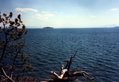
| Yellowstone Lake viewed from the West Thumb Geyser Basin | ||
| Geographical location | Wyoming ( USA ) | |
| Tributaries | Yellowstone River , Pelican Creek, Clear Creek, Beaverdam Creek, Columbine Creek | |
| Drain | Yellowstone River | |
| Islands | Frank, Stevenson, Dot, Peale, Carrington, Molly Islands (2) | |
| Places on the shore | Bridge Bay, Grant Village | |
| Data | ||
| Coordinates | 44 ° 25 ′ N , 110 ° 22 ′ W | |
|
||
| Altitude above sea level | 2357 m | |
| surface | 354 km² | |
| length | 32 km | |
| width | 24 km | |
| volume | 14.87 km³ | |
| scope | 177 km | |
| Maximum depth | 122 m | |
| Middle deep | 42 m | |

The Yellowstone Lake (formerly Lake Eustis and Sublette's Lake ), with 354 square kilometers the largest lake of Yellowstone National Park and the largest mountain lake in North America, with an elevation of over 2,000 meters. It is located at an altitude of 2,357 meters in the south of the park, in Teton County in the US state of Wyoming . With its northeastern bank, it also borders Park County . It measures a maximum of 32 km in length (north-south) and 22 km in width (east-west). The coast stretches for 177 km. The average depth is 43 m, the maximum depth is 122 m. In August, the surface temperature rises to an average of 16 ° C (60.8 ° F ); the temperature at the bottom of the lake never exceeds 5.5 ° C (42 ° F).
Yellowstone Lake is largely surrounded by forested mountains. On the west bank there is a geothermal area with hot springs and geysers .
In recent years the bottom of the lake has risen significantly; on average about 2.5 cm / year. This indicates increasing geological activity. As a result, parts of the national park were closed to tourists.
geology
During the last major eruption of the Yellowstone volcano about 640,000 years ago, the magma chamber in the interior of the Yellowstone region collapsed. A large caldera was created , which was later partially filled with lava flows . During the last ice age, a glacier largely formed the lake basin in the caldera. The water level of the original lake was 30 to 60 meters above today's level. At that time the lake stretched far into the Hayden Valley to the foot of Mount Washburn .
Yellowstone Lake emptied in different directions in the course of geological development: over the Snake River south into the Pacific , via Hudson Bay into the Atlantic and today over the Yellowstone River , Missouri River and Mississippi River into the Gulf of Mexico and from there ultimately back to the Atlantic.
natural reserve
The lake's ecosystem has been considered disturbed since the 1970s when the Arctic char was released in the lake and displaced the native Yellowstone cutthroat trout . Since 2004, ecologists have been pushing for protective measures that were implemented from 2006. Since then, Arctic char has been fished aggressively while the spawning conditions of the trout have improved. By 2014 the protective measures showed clear success. The lead scientist said the trout "got the corner" and the numbers were pointing up. The stock of the char is declining, while the number of trout among the juvenile fish is increasing significantly.
activities
Because of the cold water, swimming in the lake is not recommended, but swimming is not prohibited. Boats are available for hire at Grant Village and Bridge Bay; From Bridge Bay travelers can also take part in sightseeing tours.
Fishing licenses can be obtained from ranger stations, visitor centers, park shops and the harbor in Bridge Bay.

Geyser on Yellowstone Lake
Yellowstone Lake
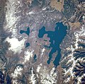
Satellite image


literature
- Aubrey L. Haines: The Yellowstone Story - A History of our First National Park , Volume One. University Press of Colorado, Niwot, 1996, ISBN 0-87081-390-0
Web links
- FAQ for Yellowstone Lake (Engl.)
Individual evidence
- ^ Trout Unlimited: 'Turning the Corner' on Yellowstone Lake , May 6, 2014