Mount Silverthrone (Alaska)
| Mount Silverthrone | ||
|---|---|---|
|
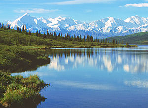
View from Wonder Lake from the north; Mount Silverthrone is the snow pyramid in the background to the left of the center of the picture |
||
| height | 4029 m | |
| location | Alaska (USA) | |
| Mountains | Alaska chain | |
| Dominance | 12.68 km → Denali (East Buttress-Peak 14630) | |
| Notch height | 987 m ↓ Traleika Col (3042 m) | |
| Coordinates | 63 ° 6 ′ 57 ″ N , 150 ° 40 ′ 32 ″ W | |
| Topo map | USGS Mount McKinley A-2 | |
|
|
||
| First ascent | April 23, 1945 by Bradford Washburn | |
The Mount Silverthrone is a 4029 m high mountain in the Alaska Range in Alaska (USA). The mountain owes its name to an expedition in the spring of 1945 that tested special equipment of the US Army under arctic conditions.
geography
The mountain is located in the central-western section of the Alaska range 17.5 km east-northeast of Denali . Located in Denali National Park , the mountain is separated from the Denali massif by the Traleika glacier flowing north . The 3042 m high altitude Traleika Col forms the deepest notch between the two mountains. The northeast flank is also drained to the north by the Brooks Glacier . The southwest flank forms the nutrient area of the South Fork Ruth Glacier , a source glacier of the Ruth Glacier .
Ascent history
Bradford Washburn made the first ascent on April 23, 1945 .
Web links
- Mount Silverthrone, Alaska on Peakbagger.com (English)
- bivouac.com
- summitpost.org

