Moyo (island)
| Moyo | ||
|---|---|---|
| Waters | Pacific Ocean | |
| Archipelago | Lesser Sunda Islands | |
| Geographical location | 8 ° 15 ′ S , 117 ° 34 ′ E | |
|
|
||
| length | 31 km | |
| width | 16 km | |
| surface | 329.8 km² | |
| Highest elevation | 671 m | |
| Residents | 6000 18 inhabitants / km² |
|
Moyo , Bahasa Indonesia : Pulau Moyo , is a 330 km² and sparsely populated Indonesian island in the administrative district ( Kabupaten ) Sumbawa of the province of West Nusa Tenggara .
location and size
Moyo lies in front of the much larger island of Sumbawa in the northwest and is separated from it by the Selat Saleh strait, which is up to 2.5 km wide . The island is 31 km long and up to 16 km wide. The coastline measures 88 km.
geography
The highest point in Moyo, the Gunung Moyo in the middle of the island, reaches 671 m. In the center there is savannah , in some places forests are expanding. From many places on the island there is a view of the highest mountain in Sumbawa, the 2821 m high Tambora volcano .
fauna
The island, surrounded by coral reefs, is largely a national park . With an area of 22,460 hectares, it takes up around two thirds of the island. On it live wild boar , monitor lizards , 21 species of bats , large herds of native deer, including barking deer , crab-eating macaques , sea turtles and many species of birds.
population
21 small villages are mainly located in the north of the island. Moyo has about 6000 inhabitants. The livelihoods of the inhabitants are agriculture and fishing.
One of the larger towns is Labuan Haji (also "Labuhan Aji"), which is surrounded by rice fields and has a school and a health station ( Puskesmas ) as well as simple shopping facilities for daily needs. In Labuan Haji ships are still built in the traditional way.
Other places on Moyo are:
- Brang Rea not far from Labuan Haji
- Sebaru not far from Cape Tanjung Sebaru, the northern tip of Moyo
- Sibotok in the northeast
- Rumah Santek on the east coast
- Brang Gado on the west coast
- Tanjung Pasir on the south coast
- Pasir Cape on the southern tip
transport
There is a ferry connection to Sumbawa Besar from Tanjung Pasir, a small port on the south coast .
tourism
Moyo is hardly affected by tourism. An upscale holiday resort was created in an isolated area in the south of the island, where there are extensive beaches with excellent diving spots. In a few places hiking trails have been created through the jungle. On several-day boat trips from Lombok to Komodo, Labuhan Haji is called at occasionally.
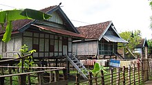
From Labuan Haji, a path about 2 km long leads past the village of Brang Rea through a piece of jungle along the Kaali river to the Diwu Mbai waterfall , where bathing is permitted. Another waterfall worth visiting is the Mata Jitu . In the jungle, massive boulders made of coral rock are remarkable. In Labuan Haji, which partly consists of stilt houses, you can watch traditional ships being built with the simplest means.
Web links
- http://www.promotingbali.com/beyond-bali/sumbawa/pulau-moyo/
- http://www.asiarooms.com/travel-guide/indonesia/lombok/wildlife-&-national-parks-in-lombok/pulau-moyo-reserve.html
- http://www.indonesialogue.com/destinations/pulau-moyo-reserve-sumbawa.html
Individual evidence
- ↑ Unep
- ↑ [1]
- ↑ Stefan Loose: Indonesia from Sumatra to Sulawesi , p. 429. Ostfildern 2013
- ↑ - ( Memento of the original from December 5, 2010 in the Internet Archive ) Info: The archive link was inserted automatically and has not yet been checked. Please check the original and archive link according to the instructions and then remove this notice.
- ↑ Anne Teffo: Indonésie , p 502. Boulogne-Billancourt 2013
- ↑ Anne Teffo: Indonésie , p 503. Boulogne-Billancourt 2013


