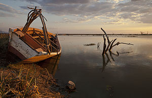
Mtera reservoir
| Mtera reservoir | |||||||||
|---|---|---|---|---|---|---|---|---|---|
| Mtera reservoir in sunset | |||||||||
|
|||||||||
|
|
|||||||||
| Coordinates | 7 ° 8 ′ 12 ″ S , 35 ° 59 ′ 16 ″ E | ||||||||
| Data on the structure | |||||||||
| Construction time: | 1975-1979 | ||||||||
| Height of the barrier structure : | 45 m | ||||||||
| Crown length: | 260 m | ||||||||
| Power plant output: | 80 MW | ||||||||
| Data on the reservoir | |||||||||
| Altitude (at congestion destination ) | 698.5 | ||||||||
| Water surface | Max. 660 km²; 190 km² at low water | ||||||||
| Reservoir length | Max. 56 km | ||||||||
| Reservoir width | Max. 15 km | ||||||||
| Total storage space : | 3.2 billion m³ | ||||||||
| Catchment area | 68 000 km² | ||||||||
The Mtera reservoir is a lake in the center of Tanzania .
location
The lake is located on the border between the two regions of Iringa and Dodoma at an altitude of 700 meters. The power plant has an output of 80 MW and was built to support the Kidatu reservoir downstream on Ruaha .
ecology
The lake is considered one of the most suitable places in Tanzania for bird watching as there are close to a million dead trees in it and it has many areas of shallow water. In addition, the water is rich in fish. In the early 1990s, around 5000 tons of fish were caught in the lake each year.
See also
Individual evidence
- ↑ Mtera. (No longer available online.) Tanzania Electric Supply Company Limited (TANESCO), archived from the original on May 7, 2012 ; accessed on May 10, 2015 . Info: The archive link was inserted automatically and has not yet been checked. Please check the original and archive link according to the instructions and then remove this notice.
- ↑ http://datazone.birdlife.org/site/factsheet/6992
- ↑ http://www.fao.org/docrep/005/v4110e/V4110E06.htm

