
Dodoma (region)
| Dodoma region | |
|---|---|
  |
|
| Basic data | |
| Country | Tanzania |
| region | Dodoma |
| surface | 41,311 km² |
| Residents | 2,083,588 (2012) |
| density | 50 inhabitants per km² |
| ISO 3166-2 | TZ-03 |
Coordinates: 5 ° 51 ′ S , 34 ° 53 ′ E
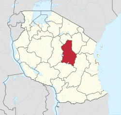
Dodoma is one of the 31 regions in Tanzania , the seat of administration is in the state capital Dodoma . The region is bounded in the north and east by the Manyara region , in the southeast by the Morogoro region , in the south by the Iringa region and in the west by the Singida region .
.jpg)
geography
The area lies in the northern part of the East African Central Plateau and in a section of the East African Rift , both of which extend from Ethiopia in the north to the south. It is between 1200 and 1500 meters above sea level. At the edges it is limited by a steep drop. The district has a hot, semi-arid climate, BSh according to the effective climate classification . The annual rainfall of 500 to 800 millimeters falls in a rainy season that lasts from November to April. The rain showers can be heavy, so that a lot of water flows off and little can be absorbed by the ground. The temperatures are very dependent on the geographical altitude, they are between 15 and 30 degrees Celsius in October. The temperature differences can also be great between day and night, with peaks of 35 degrees in the afternoon and cool nights of 10 degrees Celsius.
|
Climate table Dodoma (city)
Source: climate-data.org
|
||||||||||||||||||||||||||||||||||||||||||||||||||||||||||||||||||||||||||||||||||||||||||
history
In the colonial era, Dodoma was part of the Central Province. In 1993, Dodoma was made an independent region by separating from Singida. At first the region consisted of three provinces, later Dodoma City became a separate district. In 1995 Kongwa was separated from Mpwapwa, then in 2007 the Dodoma rural district was split up, and in 2012 Chemba was split off from Kondoa.

Administrative division
The Dodoma region is divided into seven districts:
| District | surface
km 2 |
Residents
2002 |
Residents
2012 |
|---|---|---|---|
| Dodoma | 2,576 | 322.811 | 410,956 |
| Bahi | 5,949 | 178,981 | 221,645 |
| Chamwino | 8,056 | 259.885 | 330,543 |
| Chemba | 7,653 | 192.275 | 235.711 |
| Kondoa | 5,557 | 235.815 | 269,704 |
| Kongwa | 4,041 | 248,656 | 309.973 |
| Mpwapwa | 7,479 | 253,602 | 305.056 |
population
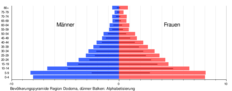
The largest ethnic groups are Gogo , Rangi and Taturu. The population grew from 1 million in 2002 to 2 million in 2012 and further to 2.4 million in 2017. The gender ratio is 95, which means that for every 100 women there are 95 men. There are deviations above all in the age group fifteen to nineteen, where there are over 105 men for every 100 women, and in the age group 25 to 29, where the ratio is 82. The literacy of the over five-year-olds is higher for men (65 percent) than for women (60 percent) and in the city with 84 percent higher than in the country with 55 percent:
|
 |

Facilities and services
- Education: There are 757 primary schools and 220 secondary schools in the district (as of 2019), and Dodoma has been a university town since 2007. Almost 90 percent of the population over five years of age have attended elementary school, ten percent have attended secondary school, two percent of men and one percent of women have completed a university degree (as of 2012).
- Health: Eight hospitals, 41 health centers and 316 pharmacies are available to provide medical care for the population (as of 2019).
Economy and Infrastructure
Of those over ten, 62 percent were employed, 16 percent worked in the household, 15 percent in a school, 3 percent unemployed and 4 percent unable to work. Almost three quarters of the employees worked in agriculture (as of 2012).
AgricultureOf 450,000 households, 377,000 are involved in agriculture, that is 92 percent of households in rural areas and eight percent of households in cities. Mainly maize is grown, in the north of the region coffee and sisal are also grown. Cattle breeding is important in all parts of the country, 200,000 farms keep livestock. The animals kept most frequently are chickens, goats and cattle (as of 2012). |
 |

Craft and service
Around three percent of the population were craftsmen and five percent were engaged in services (as of 2012).
transport
- Railway: The Tanganyika Railway connects Dodoma with the port of Dar es Salaam in the east and leads to Kigoma in the west . The line was built in 1914 as a 1000 millimeter narrow-gauge railway and is 1254 kilometers long. In 2017, the expansion to an electrified standard-gauge railway began in Dar es Salaam, and in 2018 the second phase of the conversion from Morogoro to Dodoma and on to Makutupora began.
- Road: The paved national road T3 connects Dodoma with Dar es Salaam. It continues in the northwest to Singida and Rwanda . Dodoma is also located on the north-south national road T5 from Arusha to Iringa , which is also paved throughout the region (as of 2020). The region has a total of 555 kilometers of paved trunk roads, 1,142 kilometers of regional roads and 6,486 kilometers of district roads, only 26 kilometers of regional roads and 108 kilometers of district roads are asphalted. More than three quarters of the streets are also passable in the rainy season (as of 2019).
- Airport: From 2000 to 2016 the airport in Dodoma had around 10,000 passengers per year, in 2018 this number rose to 46,000.
Nature reserves, sights
.jpg)
Kondoa rock paintings
Scenes from the lives of hunters and gatherers have been painted on overhanging rocks for 2000 years. This collection of images in over 150 locations near Kondoa was declared a UNESCO World Heritage Site in 2006
_(28996636076).jpg)
.jpg)
Nature parks
- Ruaha National Park : With 20,300 square kilometers, the largest national park in Tanzania is located in the three regions of Iringa, Mbeya and Dodoma. It is known for its large numbers of predators. In addition to large herds of lions, there are also the rare wild dogs.
- Tarangire National Park : Tarangire National Park is 2,850 square kilometers and is located in the three regions of Dodoma, Arusha and Manyara. In addition to its wealth of animals, it is known for the African baobab trees , which are also called baobab.
- Swagaswaga animal reserve
- Mkungunero animal reserve on the border with Manyara

Sights of the capital Dodoma
The main attractions of the capital Dodoma are the Nyerere Square, the Gaddafi Mosque, the Catholic Cathedral and the University .
Web links
Individual evidence
- ↑ a b c d e Profiles | Dodoma region. Retrieved December 6, 2019 .
- ^ Maps of the World. Russian Army Maps, S. Map 500k - xb36-2, Map 500k - xb37-1, Map 500k - xb36-4, Map 500k - xb37-3 , accessed December 2, 2019 (Russian).
- ↑ Dodoma climate: Average Temperature, weather by month, Dodoma weather averages - Climate-Data.org. Retrieved December 6, 2019 .
- ^ Tanzania Regional Profiles, 01 Dodoma Regional Profiles. (pdf) The United Republic of Tanzania, 2016, p. 15 , accessed on October 20, 2019 .
- ↑ Profiles | Dodoma region. Retrieved December 6, 2019 .
- ↑ The Economic Survey 2017. (pdf) The United Republic of Tanzania, July 2018, p. 85 , accessed December 7, 2019 .
- ^ Tanzania Regional Profiles, 01 Dodoma Regional Profiles. (pdf) The United Republic of Tanzania, 2016, pp. 18, 63 , accessed on October 20, 2019 .
- ↑ a b Statistics | Dodoma region. Retrieved December 7, 2019 .
- ^ The University of Dodoma. Retrieved December 8, 2019 .
- ^ Tanzania Regional Profiles, 01 Dodoma Regional Profiles. (pdf) The United Republic of Tanzania, 2016, p. 81 , accessed on October 20, 2019 .
- ^ Tanzania Regional Profiles, 01 Dodoma Regional Profiles. (pdf) The United Republic of Tanzania, 2016, pp. 91–92 , accessed on October 20, 2019 .
- ^ Tanzania Regional Profiles, 01 Dodoma Regional Profiles. (pdf) The United Republic of Tanzania, 2016, pp. 125–130 , accessed on October 20, 2019 .
- ↑ Dodoma | national capital, Tanzania. Encyclopaedia Britannica, accessed December 8, 2019 .
- ^ Dodoma Region Investment Guide. (pdf) Tanzania Regional Administration and Local Government, 2019, p. 13 , accessed December 8, 2019 .
- ^ Modal Choice between Rail and Road Transportation, Evidence from Tanzania. World Bank Group, August 2017, pp. 7–8 , accessed November 3, 2019 .
- ^ Tanzania Railways Corporation, Standard Gauge Railway. The United Republic of Tanzania, accessed December 8, 2019 .
- ^ Tanzania Trunk Road Network. The United Republic of Tanzania, accessed December 8, 2019 .
- ^ Dodoma Region Roads Network. (PDF) February 2020, accessed on August 4, 2020 .
- ^ Dodoma Region Investment Guide. (pdf) Tanzania Regional Administration and Local Government, 2019, p. 9 , accessed December 8, 2019 .
- ↑ Tanzania in Figures 2018. (pdf) National Bureau of Statistics, June 2019, p. 67 , accessed December 8, 2019 .
- ↑ UNESCO World Heritage Center: Kondoa Rock-Art Sites. Retrieved December 8, 2019 .
- ↑ a b c d Tanzania in Figures 2018. (pdf) National Bureau of Statistics, June 2019, pp. 8–9 , accessed on December 8, 2019 .
- ↑ Ruaha National Park - Travel Guide, Map & More! Retrieved December 8, 2019 .
- ^ Tarangire National Park travel. Retrieved December 8, 2019 .
- ↑ THE 5 BEST Things to Do in Dodoma - 2019 (with Photos) - TripAdvisor. Retrieved December 8, 2019 .
- ↑ Lonely Planet: Attractions in Dodoma, Tanzania. Retrieved December 8, 2019 .
Arusha | Dar es Salaam | Dodoma | Geita | Iringa | Kagera | Katavi | Kigoma | Kilimanjaro | Lindi | Manyara | Mara | Mbeya | Morogoro | Mtwara | Mwanza | Njombe | Pemba Kaskazini | Pemba Kusini | Pwani | Rukwa | Ruvuma | Shinyanga | Simiyu | Singida | Songwe | Tabora | Thong | Unguja Kaskazini | Unguja Kusini | Unguja Mjini Magharibi