
Shinyanga (region)
| Shinyanga | |
|---|---|
  |
|
| Basic data | |
| Country | Tanzania |
| region | Shinyanga |
| surface | 18,555 km² |
| Residents | 1,534,808 (2012) |
| density | 83 inhabitants per km² |
| ISO 3166-2 | TZ-22 |
Coordinates: 3 ° 21 ′ S , 32 ° 5 ′ E
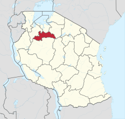
Shinyanga is one of the 31 regions in Tanzania , the seat of the administration is in the city of Shinyanga . The region is bordered by the Mwanza region to the north, the Simiyu region to the east, the Tabora region to the south and the Geita region to the west .

geography
The region is 18,555 square kilometers and has 1,534,808 inhabitants (as of 2012). It is located in the northwest of Tanzania and is part of the lake area. The area is at an altitude of 1000 to 1500 meters above sea level.
The climate in Shinyanga is a tropical savanna climate, Aw according to the effective climate classification . The months June to September are very dry, the temperature is consistently high with a slight cooling in the dry season.
|
Climate table Shinyanga
Source: climate-data.org
|
||||||||||||||||||||||||||||||||||||||||||||||||||||||||||||||||||||||||||||||||||||||||||
history
In 1963, the Shinyanga region was formed from the former maritime province. When the administrative structures were redefined in 1997, the Simiyu region was split off, which was the hour of birth of the region in its current form.
Administrative division
The Shinyanga region is divided into three districts, six councils and 126 parishes (wards):

| District | Council | surface
km 2 |
Residents
2002 |
Residents
2012 |
number
Communities |
|---|---|---|---|---|---|
| Kahama | Kahama TC | 1,515 | 161,547 | 242.208 | 20th |
| Ushetu DC | 5,311 | 433,344 | 523,802 | 20th | |
| Msalala DC | 2,637 | 18th | |||
| Kishapu | Kishapu DC | 4,334 | 239,305 | 272.990 | 25th |
| Shinyanga | Shinyanga DC | 4.212 | 276.393 | 334.417 | 26th |
| Shinyanga MC | 548 | 134,523 | 161.391 | 17th | |
| total | Shinyanga region | 18,555 | 1,245,112 | 1,534,808 | 126 |
population
The largest ethnic group in Shinyanga are the Sukuma , who, with more than one million members, are one of the largest population groups in Tanzania.
The average household size in 2012 was 5.8 people. The average age at marriage increased for men from 24.2 years in 2002 to 26 years in 2012, and for women from 19.2 to 22.2 years in the same period. The population is very young, almost half of the population is under fifteen. It is noticeable that the gender ratio is balanced up to the age of fifteen and those over forty, but in between there are more women than men, so between the ages of 20 and 24 there are only 84 men for every hundred women:

Facilities and servicesShinyanga is one of the poorest regions in Tanzania, characterized by high birth rates among young people and marriages of children.
|
 |


- Water: 43 percent of the population, 32 percent of the rural population and 81 percent in the city had a supply of good drinking water. This includes tap water in the house or in public, as well as protected wells and springs. 57 percent obtained their water from unprotected springs, rainwater, from bodies of water or were supplied with water in a tank.
Economy and Infrastructure
The most important industry in the region is agriculture, around 80 percent of the population live from it. A study in 120 households shows that in 2014 more than half of the income came from agriculture, more than a quarter from livestock and seven percent from forestry.
Agriculture
Two thirds of the total area of 18,555 square kilometers is suitable for agriculture, of which around 60 percent is cultivated (as of 2018). Millet, rice, maize, sweet potatoes and manioc are mainly grown for their own consumption, while cotton, tobacco, sunflowers, lentils, nuts, linseed and sesame are intended for sale.
In addition to agriculture, animal husbandry is an important source of income. In 2018, 1.2 million cattle, 760,000 goats, 370,000 sheep and 2 million chickens were kept in the region. The majority of the animals are native breeds.
forestry
The area originally had large acacia and miombo forests. They were cleared to eradicate the tsetse flies, which are malaria vectors, and to enlarge the agricultural land. In 1986, President Julius Nyerere, together with the government of Norway and several NGOs, started a reforestation program that restored around 30,000 hectares of forest by 2004.
Mining

Diamonds are found in Mwadui and gold is mined in Bulyanhulu and Buzwagi. The diamond mine in Mwadui has been in operation since 1940. In 2019, 400,000 carats of diamonds were found at a depth of 580 meters. In 2011, 2,000 workers extracted 5.6 tons of gold from the gold mine in Buzwagi, and in Bulyanhulu 7.4 tons were mined with 2,850 workers in the same year.
Infrastructure
- Railway: The northern stretch of the Tanganyika Railway from Dar es Salaam to Mwanza runs through Shinyanga .
- Roads: The T8 national road runs through Shinyanga. It is an important north-south connection in Tanzania, running from Mbeya in the south to Mwanza in the north.
Attractions
- Kigosi Game Reserve : The 7000 square kilometer game reserve is located in the west of the region and also extends into the Tabora region. It was established in 1983 and has the largest wetland of all East African reserves. It is particularly rich in birds and mammals.
- Maswa Game Reserve : The Maswa Game Reserve extends over the Simiyu and Shinyanga regions and is 2200 square kilometers. It was established in 1962. Its acacia and fig trees as well as large populations of buffalo, lions, antelopes, Thomson's gazelles and leopards are particularly worth seeing.
Web links
Individual evidence
- ↑ a b c History | Shinyanga region. Retrieved November 28, 2019 .
- ^ A b Andina Auria, Dwi Putri, Demetrius L Kweka: The Case of Ngitilis in the Shinyanga Region, Tanzania. In: REDD + on the ground. Center for International Forestry Research., 2014, accessed November 29, 2019 .
- ↑ Maps for thr World, Map 500k - xa36-3, Map 500k - xa36-4. Russian Army Maps, accessed November 26, 2019 (in Russian).
- ↑ Climate Shinyanga: Temperature, climate graph, Climate table for Shinyanga - Climate-Data.org. Retrieved November 29, 2019 .
- ↑ John Ndembwike: Tanzania: The Land and Its People . New Africa Press, 2006, pp. 31 .
- ^ Basic Demographic and Socio-Economic Profile. (pdf) National Bureau of Statistics, April 2014, pp. 42, 52 , accessed December 1, 2019 .
- ^ Tanzania Regional Profiles, 17th Shimnyanga Regional Profile. (pdf) The United Republic of Tanzania, pp. 18, 62 , accessed on November 23, 2019 .
- ^ Opportunities and possibilities Shinyanga Region. (pdf) United Nations Population Fund, accessed December 1, 2019 .
- ^ Social Economics of Tanzania, 2016 - Tanzania Data Portal. Accessed December 1, 2019 .
- ^ Tanzania Regional Profiles, 17th Shimnyanga Regional Profile. (pdf) The United Republic of Tanzania, p. 72 , accessed on November 23, 2019 .
- ↑ Tanzania Demographic and Health Survey 2015-2016. (pdf) Ministry of Health, Community Development, Gender, Elderly and Children, December 2016, p. 181 , accessed on December 1, 2019 .
- ^ Tanzania Regional Profiles, 17th Shimnyanga Regional Profile. (pdf) The United Republic of Tanzania, p. 121 , accessed on November 23, 2019 .
- ^ Tanzania Regional Profiles, 17th Shimnyanga Regional Profile. (pdf) The United Republic of Tanzania, p. 110 , accessed on November 23, 2019 .
- ↑ Economic Activity: Agriculture | Shinyanga region. Regional Administration and Local Government, accessed November 29, 2019 (Swahili).
- ↑ Economic Activity: Agriculture | Shinyanga region. Regional Administration and Local Government, accessed November 29, 2019 (Swahili).
- ↑ Economic Activity: Cattle Breeding | Shinyanga region. Regional Administration and Local Government, accessed November 29, 2019 (Swahili).
- ↑ Edmund Barrow: 300,000 Hectares Restored in Shinyanga, Tanzania . In: SAPIEN.S. Surveys and Perspectives Integrating Environment and Society . No. 7.2 , April 23, 2014, ISSN 1993-3800 ( openedition.org [accessed December 1, 2019]).
- ^ Restoration Resource Center Tanzania: Forest Restoration in the Shinyanga Region. Accessed December 1, 2019 .
- ↑ Economic Activities: Mining | Shinyanga region. Regional Administration and Local Government, accessed November 29, 2019 (Swahili).
- ↑ Petra Diamonds | Williamson. Retrieved November 29, 2019 .
- ↑ Buzwagi Gold Mine, Shinyanga. In: Mining Technology | Mining News and Views Updated Daily. Retrieved November 29, 2019 (UK English).
- ↑ Bulyanhulu Gold Mine, Kahama, Shinyanga. In: Mining Technology | Mining News and Views Updated Daily. Retrieved December 1, 2019 (UK English).
- ^ Trunk Roads Network. (pdf) Accessed November 30, 2019 .
- ^ Tanzania, Trunk Road Network. (pdf) The United Republic of Tanzania, accessed November 30, 2019 .
- ↑ a b Tanzania in Figures 2018. (pdf) The United Republic of Tanzania, June 2019, p. 9 , accessed on November 30, 2019 .
- ↑ a b Visit Tanzania | Game reserves. Retrieved November 30, 2019 .
Arusha | Dar es Salaam | Dodoma | Geita | Iringa | Kagera | Katavi | Kigoma | Kilimanjaro | Lindi | Manyara | Mara | Mbeya | Morogoro | Mtwara | Mwanza | Njombe | Pemba Kaskazini | Pemba Kusini | Pwani | Rukwa | Ruvuma | Shinyanga | Simiyu | Singida | Songwe | Tabora | Thong | Unguja Kaskazini | Unguja Kusini | Unguja Mjini Magharibi