
Kagera (region)
| Kagera | |
|---|---|
  |
|
| Basic data | |
| Country | Tanzania |
| Capital | Bukoba |
| surface | 40,838 km² |
| Residents | 2,458,023 (2012) |
| density | 60 inhabitants per km² |
| ISO 3166-2 | TZ-05 |
Coordinates: 2 ° 0 ′ S , 31 ° 30 ′ E

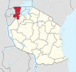
The administrative region of Kagera is located in the far northwest of Tanzania . The administrative seat of the region is Bukoba on Lake Victoria . The region itself is divided into the seven administrative districts of Bukoba , Biharamulo , Karagwe , Kyerwa , Missenyi , Muleba and Ngara . The region borders Uganda in the north, Rwanda and Burundi in the west . Within Tanzania, the administrative regions of Geita and Kigoma in the south and Lake Victoria in the east are neighboring.
Surname
The region is named after the river Kagera , which rises in Rwanda, then flows through the north of the region and finally flows into Lake Victoria. The Kagera is seen as part of the Nile as the Nile emerges from Lake Victoria in the north. The region was formerly known as the West Lake Region . In 1979 it was renamed Kagera. The trigger was the war between Tanzania and Uganda, in which the then dictator of Uganda Idi Amin tried to permanently annex the region.
geography
Kagera lies south of the equator between 01 ° 00 'and 02 ° 45' south and between 30 ° 25 'and 32 ° 40' east. This includes large parts of Lake Victoria. The eastern border marks the island of Nabuyongo .
surface
The region has an area of 40,838 km². Of this, 28,953 km² consist of land mass and the remaining 11,885 km² are the bodies of water of Lake Victoria and the Ikimba , Burigi , Ngono and Kagera lakes . The Kagera region is the fifteenth largest region in Tanzania. This corresponds to 3.2 percent of the area of Tanzania.
population
According to a 2003 national census, the population was 2,003,888 people, with an annual growth rate of 3.1 percent. With the 2012 census there were already 2,458,023 inhabitants. In the eastern part of the region mainly people of the Haya live and in the western part members of the Nyambo .
Climate and vegetation
The Kagera region has fertile soils . However, some of these have become poor in nutrients due to intensive agricultural use . Precipitation falls abundantly. The prevailing easterly winds bring rainy clouds from Lake Victoria, which leads to almost evergreen vegetation in the region.
history
The kingdoms of the Buhaya
In the 19th century, nine kingdoms were formed in Buhaya - the land that was settled by the Haya ethnic group - on the west coast of Lake Victoria. These were called: Kihanja, Karagwe, Kiziba, Misenye, Bugabo, Kyamtwara, Ihangiro, Bukara and Biharamulo and were strongly hierarchical compared to other contemporary African societies. The kings - also called Omukamas after the local language - lived in developed palaces and legitimized themselves as direct descendants of gods. They had the income from a differentiated tax system.

Before the arrival of the colonial rulers, the inhabitants of the kingdoms began to grow coffee and bananas . This remained in the hands of local farmers until independence and above all the Omukamas, who made some wealth during this time. One of the reasons for this was that the number of white settlers in the region remained negligibly small, displacing local farmers in other parts of Africa such as the highlands of Kenya, for example. Since the region - located far in the interior of Africa - did not have any noteworthy transport links, this condition was preserved.
Colonial times
The colonial occupation of Kagera took place in 1890 by the Germans, who incorporated the region into the colony of German East Africa . A fort was built in Bukoba and officers of the protection force were dispatched. The Buhaya kingdoms initially took advantage of this occupation. Because the German troops guarantee protection from slave collectors and the Baganda . The Baganda lived north of Lake Victoria in what is now Uganda. They invaded the kingdoms of the Bahaya several times and did not tolerate any other boats on Lake Victoria. At the turn of the century, the Germans made the Omukamas subject to tribute, but left the Bahayan tax system untouched. The Evangelical Lutheran Church founded the first missions in Kagera. But other missions such as the Roman Catholic Church (the White Fathers ) also developed brisk activity in the region over time. After the First World War , the Kagera region, like the rest of Tanzania, came under British rule. As under German rule, the British left the Omukamas as middlemen and exercised indirect rule over the area. The Hayas founded one of the first interest groups in East Africa for an ethnic group: the Bahaya Union .
After the independence of Tanzania
In 1964 - after Tanzania gained independence - Julius Nyerere , the first president of the country, dissolved the Buhaya kingdoms. He saw in them an obstacle to the national unity of the post-colonial state. With the drop in the price of coffee and the war with Uganda in 1979, the once prosperous economy of the region fell behind other regions in Tanzania.
Administrative division
The region is divided into seven districts and eight constituencies (councils):
| District | Council | surface
km² |
Residents
(1988) |
Residents
(2002) |
Residents
(2012) |
|---|---|---|---|---|---|
| Biharamulo | Biharamulo | 5,627 | 209.279 | 159,055 | 323,486 |
| Bukoba | Bukoba District Council | 5,071 | 340,800 | 241.234 | 289,697 |
| Bukoba Municipal Council | 80 | 46.503 | 80,868 | 128,796 | |
| Karagwe | Karagwe | 4,630 | 284.137 | 201,446 | 332.020 |
| Kywerwa | Kywerwa | 3,086 | - | 222,841 | 321.026 |
| Missenyi | Missenyi | 2,709 | - | 152.786 | 202.632 |
| Muleba | Muleba | 10,739 | 273,329 | 385.184 | 540.310 |
| Ngara | Ngara | 3,744 | 159,546 | 334,409 | 320.056 |
economy
The economy is primarily geared towards the agricultural sector. The most important crops for export are coffee , bananas and, increasingly, tea . In addition, corn , sweet potatoes and, above all, plantains are grown for their own consumption.
tourism
Kagera is an important transit region for tourists to Rwanda, Uganda and the interior of Tanzania. There is a ferry and airline service between Bukoba and Mwanza , the largest city in Tanzania on Lake Victoria. The nearest major airport is Entebbe International Airport near Kampala in Uganda. There is a regular bus route between Kampala and Bukoba. The Kagera region is home to a number of national parks : Burigi , Biharamulo , Ibanda , Kimisi and Rumanyiko-Orugundu . There is also a Rubondo National Park on the island of the same name in the southwest of Lake Victoria. The name-related Kagera National Park is not in Tanzania, but on the other side of the border river Kagera in Rwanda.
Web links
- Official website of the Kagera Region (English)
Individual evidence
- ↑ Mwanzo | Districts. Retrieved July 2, 2020 .
- ^ National Bureau of Statistics & Office of Chief Government Statistician: Basic Demographic and Socio-Economic Profile, Statistical Tables, Tanzania Mainland ( Memento of May 16, 2018 in the Internet Archive ). Dar es Salaam, Zanzibar 2014, on www.tanzania.go.tz, PDF document p. 15 (English)
- ↑ Kilimo | Agriculture. Retrieved June 25, 2020 (Swahili).
Arusha | Dar es Salaam | Dodoma | Geita | Iringa | Kagera | Katavi | Kigoma | Kilimanjaro | Lindi | Manyara | Mara | Mbeya | Morogoro | Mtwara | Mwanza | Njombe | Pemba Kaskazini | Pemba Kusini | Pwani | Rukwa | Ruvuma | Shinyanga | Simiyu | Singida | Songwe | Tabora | Thong | Unguja Kaskazini | Unguja Kusini | Unguja Mjini Magharibi