Ruaha
| Ruaha | ||
|
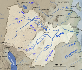
The Great Ruaha in the Rufiji catchment area (center) |
||
| Data | ||
| location |
|
|
| River system | Rufiji | |
| Drain over | Rufiji → Indian Ocean | |
| Headwaters | Kipengere Mountains | |
| muzzle |
Rufiji coordinates: 7 ° 55 ′ 55 " S , 37 ° 47 ′ 47" E 7 ° 55 ′ 55 " S , 37 ° 47 ′ 47" E |
|
| Mouth height | approx. 122 m
|
|
| length | 900 km | |
| Catchment area | 85,554 km² | |
| Discharge at the Mtera gauge (1286660) A Eo : 67,950 km² |
NNQ (min. Month Ø) MNQ 1954–1979 MQ 1954–1979 Mq 1954–1979 MHQ 1954–1979 HHQ (max. Month Ø) |
0 l / s 5 m³ / s 124 m³ / s 1.8 l / (s km²) 305 m³ / s 926 m³ / s |
| Left tributaries | Kisigo | |
| Right tributaries | Little Ruaha | |
| Reservoirs flowed through | Mtera Reservoir , Kidatu Reservoir | |
|
The Great Ruaha at the foot of the Udzungwa Mountains |
||
The Ruaha - also called Great Ruaha - is a river in southern Tanzania .
course
It rises in the Kipengere Mountains and flows over 900 kilometers into the Selous Game Reserve - 10 kilometers north of Masagura in the Rufiji .
In fact, with the Kilombero River , a source river of the Ruiji, it drains all areas of the southern highlands of Tanzania east of Mount Rungwe . It has its own headwaters in the Mbeya Range , the Poroto Mountains , the Kitulo Plateau and the northern Kipengere Mountains . The Ruaha collects the water of its catchment area first in the swampy but extremely fertile Usangu plains northeast of Mbeya , flows southeast along the Ruaha National Park to the Rubeho Mountains , before which it turns to the southeast, the northern boundary of the Udzungwa Mountains National Parks , then passes the Selous Wildlife Sanctuary to the north and flows into the Rufiji.
Hydrometry
The runoff of the Ruaha was measured in m³ / s at the Mtera gauge.

Water management
The power stations of the Mtera Reservoir (80 MW ) and the Kidatu Dam (240 MW) on Ruaha generate half of Tanzania's electricity. The water of the Ruaha is used extensively for irrigation of rice crops in such a way that it no longer carries water in its lower parts for almost a third of the year. In July 2011, a million people on the lower Ruaha were already stuck in a water crisis.
Web links
Individual evidence
- ^ Rufiji Basin Water Board - 2012-13 Rufiji Basin Annual Hydrological Report
- ↑ a b Failure of the Mtera-Kidatu Reservoir System in the Early 1990s
- ↑ GRDC - level Mtera
- ↑ a b Travel map East Africa (1: 2,000,000) . In: Ravenstein Kartographie (Ed.): International travel map . Sheet 6899. Ravenstein-Verlag, Bad Sooden / Taunus 1994, ISBN 3-87660-899-6 .
- ↑ afrika.info, January 18, 2013

