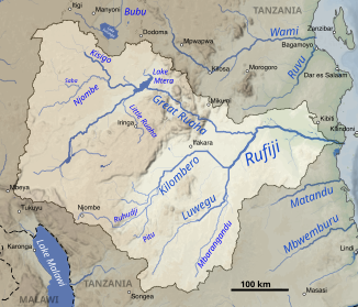
Little Ruaha
| Little Ruaha | ||
|
The Little Ruaha in the Rufiji catchment area (center) |
||
| Data | ||
| location |
|
|
| River system | Rufiji | |
| Drain over | Ruaha → Rufiji → Indian Ocean | |
| source | Near the town of Mafinga in the Iringa region, 8 ° 20 ′ 15 ″ S , 35 ° 16 ′ 50 ″ E |
|
| Source height | about 1950 m | |
| muzzle | Shortly before the Mtera reservoir in the Ruaha Coordinates: 7 ° 15 ′ 23 ″ S , 35 ° 32 ′ 46 ″ E 7 ° 15 ′ 23 ″ S , 35 ° 32 ′ 46 ″ E |
|
| Mouth height | 713 m | |
| Height difference | about 1237 m | |
| Bottom slope | about 4.1 ‰ | |
| length | about 300 km | |
| Catchment area | 5545 km² | |
| Discharge at the Mawande A Eo gauge : 5193 km² |
NNQ (November 26, 1959 ) MNQ 1956–1959 MQ 1956–1959 Mq 1956–1959 MHQ 1956–1959 HHQ (April 19, 1957) |
2 m³ / s 5 m³ / s 19 m³ / s 3.7 l / (s km²) 49 m³ / s 164 m³ / s |
| Medium-sized cities | Iringa | |
| Small towns | Mafinga | |
The Little Ruaha is a river in Tanzania .
course
The river has its source near the town of Mafinga in the Iringa region . It flows north-east and makes a long bend to the left shortly before the town of Iringa , which it flows through. Shortly after the city it bends to the northwest, about 50 km further, shortly before the Mtera reservoir , flows into the (Great) Ruaha.
Hydrometry
Average monthly flow of Little Ruaha (1956–1959) measured at the hydrological station in Mawande in m³ / s.

use
The Little Ruaha flows through semi-arid areas. Since it usually has water all year round, it is particularly important for irrigation and livestock farming. Like many other rivers in the Rufiji catchment area, it is also used to generate energy through hydropower plants. The precipitation conditions in the catchment area moved in the last 30 years between 500 and 1000 mm, with a decreasing tendency due to climate change. In addition, land use has changed significantly during this period. Forest areas were cleared for arable farming. The pressure on resources has also increased due to the growing population. Due to the interaction of these factors, the runoff has decreased significantly since 1980.
Individual evidence
- ↑ a b c Google Earth
- ↑ Soviet General Staff Map , accessed via http://loadmap.net/
- ^ A b c The Rufiji Basin Tanganyika - FAO Report to the Government of Tanganyika on the Preliminary Reconnaissance Survey of the Rufiji Basin
- ^ Assessing the Hydrology of a Data-Scarce Tropical Watershed Using the Soil and Water Assessment Tool: Case of the Little Ruaha River Watershed in Iringa, Tanzania
- ↑ Interventions in land use practices and climate variability / change adaptation needed to reverse declining water resource in little Ruaha river
