Kilombero (river)
|
Kilombero Ulanga |
||
|
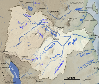
Kilombero in the Rufiji catchment area (center) |
||
| Data | ||
| location |
|
|
| River system | Rufiji | |
| Drain over | Rufiji → Indian Ocean | |
| confluence | of the Ruhudi with the Mnyera in the Kilombero plain | |
| confluence | with Luwegu to Rufiji Coordinates: 8 ° 31 ′ 17 ″ S , 37 ° 20 ′ 33 ″ E 8 ° 31 ′ 17 ″ S , 37 ° 20 ′ 33 ″ E
|
|
| Catchment area | 40,330 km² | |
| Discharge at the Swero A Eo gauge : 33,400 km² Location: 100 km above the mouth |
NNQ (10.1981) MNQ 1968–1981 MQ 1968–1981 Mq 1968–1981 MHQ 1968–1981 HHQ (04.1962) |
29.7 m³ / s 141 m³ / s 447 m³ / s 13.4 l / (s km²) 1180 m³ / s 2639 m³ / s |
| Left tributaries | Kihansi | |
| Medium-sized cities | Ifakara | |
|
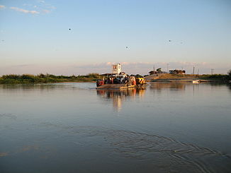
Ferry over the Kilombero near Ifakara |
||
The Kilombero (also called Ulanga) is a river in southern Tanzania , in the administrative region of Morogoro . It is the most water-rich river in the Rufiji catchment area.
course
The river has its headwaters over its main headwaters , the Ruhudi , in the southern Kipengere Mountains a little south of Njombe . It reaches the Kilombero or Ulanga plains, an elongated swamp plain between the Udzungwa Mountains and the Mahenge Plateau in which the river divides into many side arms. At its southern entrance it takes on several strongly flowing rivers. It bears the name Kilombero from the mouth of the Mnyera . It flows in a north-easterly direction through the plains to the town of Ifakara, where it leaves the plains and bends to the south-east, towards Selous game reserve. It unites with the Luwegu in the reserve at the Suguli Falls . From then on the water is called Rufiji .
Hydrometry
The runoff of Kilombero was measured for 13 years (1968–1981) at the Swero gauge, about 100 km above the mouth in m³ / s.

Resource management
On the Kihansi , a tributary of the Kilombero, an electricity plant produces 180 kW . The water of the Kilombero is used extensively to irrigate rice crops in the Kilombero Valley in such a way that it no longer carries water in its lower parts for almost a third of the year.
Individual evidence
- ^ Rufiji Basin Water Board - 2012-13 Rufiji Basin Annual Hydrological Report
- ↑ a b PANGEA - Data Publisher for Earth & Environmental Science
- ^ Rufiji Basin Water Board - 2012-13 Rufiji Basin Annual Hydrological Report

