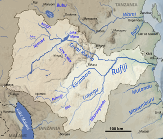
Ruhudi
|
Ruhudi Ruhuji |
||
|
The Ruhudi in the Rufiji catchment area (bottom center) |
||
| Data | ||
| location |
|
|
| River system | Rufiji | |
| Drain over | Kilombero → Rufiji → Indian Ocean | |
| source | In the district of Njombe , about 10 km southwest of Njombe 9 ° 24 ′ 12 ″ S , 34 ° 41 ′ 46 ″ E |
|
| Source height | approx. 2000 m | |
| muzzle | Confluence with the Mnyera and formation of the Kilombero Coordinates: 9 ° 3 ′ 59 ″ S , 35 ° 56 ′ 20 ″ E 9 ° 3 ′ 59 ″ S , 35 ° 56 ′ 20 ″ E |
|
| Mouth height | 295 m | |
| Height difference | approx. 1705 m
|
|
| Catchment area | 8578 km² | |
| Discharge at the Mwayamalungu A Eo gauge : 8531 km² |
NNQ (November 24, 1959) MNQ 1956–1958 MQ 1956–1958 Mq 1956–1958 MHQ 1956–1958 HHQ ( April 18, 1957 ) |
23 m³ / s 34 m³ / s 99 m³ / s 11.6 l / (s km²) 237 m³ / s 425 m³ / s |
| Right tributaries | Pitu | |
The Ruhudi is a river in Tanzania .
course
The river has its source in the Njombe region about 10 km southwest of Njombe on the watershed to Lake Malawi, only 70 km away . Its course leads roughly in a north-northeast direction through a narrow and steep valley. It reaches the Kilombero plain, where it receives the Pitu from the south. A little later it unites with the Mnyera from the west and forms the Kilombero with it .
It is considered to be the source of the Rufiji.
Hydrometry
Average monthly flow of the Ruhudi (1956–1959) measured at the hydrological station in Mwayamalungu in m³ / s.

