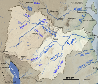
Kisigo
| Kisigo | ||
|
The Kisigo in the Rufiji catchment area (top left) |
||
| Data | ||
| location |
|
|
| River system | Rufiji | |
| Drain over | Ruaha → Rufiji → Indian Ocean | |
| muzzle | From the west into the Mtera reservoir Coordinates: 7 ° 5 ′ 0 ″ S , 35 ° 43 ′ 0 ″ E 7 ° 5 ′ 0 ″ S , 35 ° 43 ′ 0 ″ E |
|
| Mouth height |
700 m
|
|
| Catchment area | 26,433 km² | |
| Outflow at the Kinunguru A Eo gauge: 24,543 km² |
MNQ 1957–1959 MQ 1957–1959 Mq 1957–1959 MHQ 1957–1959 HHQ (04/30/1959) |
0 l / s 11 m³ / s 0.4 l / (s km²) 62 m³ / s 269 m³ / s |
| Right tributaries | Njombe | |
The Kisigo is a river in Tanzania . It is seasonal as it drains an area with little rain, but it is prone to sudden flooding. It is the largest of the Ruaha tributaries coming from the west .
Hydrometry
Average monthly flow through the Kisigo measured at the hydrological station in Kinunguru in m³ / s. Like most rivers in the region, the Kisigo flows depending on the rainy season.

