Njombe (river)
| Njombe | ||
|
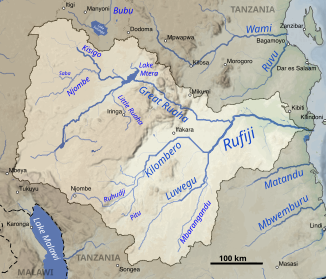
The Njombe in the Rufiji catchment area (top left) |
||
| Data | ||
| location |
|
|
| River system | Rufiji | |
| Drain over | Kisigo → Ruaha → Rufiji → Indian Ocean | |
| source | In the Mbeya region about 200 km west of Iringa 7 ° 51 ′ 0 ″ S , 33 ° 55 ′ 0 ″ E |
|
| Source height | about 1650 m | |
| muzzle | On the border between the Iringa and Dodoma regions in the Kisigo, about 70 km west of the Mtera reservoir . Coordinates: 6 ° 58 ′ 0 ″ S , 35 ° 9 ′ 15 ″ E 6 ° 58 ′ 0 ″ S , 35 ° 9 ′ 15 ″ E |
|
| Mouth height | 968 m | |
| Height difference | about 682 m | |
| Bottom slope | about 2.7 ‰ | |
| length | about 250 km | |
| Catchment area | 14,102 km² | |
| Discharge at the gauge Ifumba A Eo : 14,084 km² |
MNQ 1957–1959 MQ 1957–1959 Mq 1957–1959 MHQ 1957–1959 HHQ (03/30/1959) |
0 l / s 8 m³ / s 0.6 l / (s km²) 48 m³ / s 295 m³ / s |
| Left tributaries | Saba | |
The Njombe is a river in Tanzania .
course
The river has its source in the Mbeya region about 200 km west of Iringa in southwest Tanzania at an altitude of about 1650 meters. Initially it runs in a northerly direction. Shortly after crossing the border with the Singida region , it changes course to east-northeast and runs along the border with the Iringa region . From the source it forms the border to the Ruaha National Park . At the northern tip of the park, it bends 90 ° to the right and flows into the Kisigo about 30 km further on the border between the Iringa and Dodoma regions .
Hydrometry
Average monthly flow of the Njombe measured at the hydrological station in Ifumbe in m³ / s.

