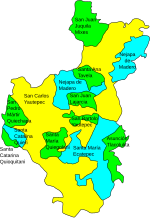
Municipio of San Carlos Yautepec
| San Carlos Yautepec | |
|---|---|

|
|
| Basic data | |
| Country | Mexico |
| State | Oaxaca |
| Seat | San Carlos Yautepec |
| surface | 2,312.4 km² |
| Residents | 11,813 (2010) |
| density | 5.11 inhabitants per km² |
| INEGI no. | 20125 |
| politics | |
| Presidente municipal | Renan Zarate Rosales |
Coordinates: 16 ° 30 ′ N , 96 ° 6 ′ W
San Carlos Yautepec is a municipality in the Mexican state of Oaxaca . The municipality extends over an area of 2312.4 km², the 2010 census counted 11,813 inhabitants in the municipality. The administrative headquarters are in San Carlos Yautepec of the same name .
geography
The municipality of San Carlos Yautepec is located between sea level and 3600 m in the Yautepec district of the Sierra Sur region . It belongs entirely to the physiographic province of the Sierra Madre del Sur , of which 69% are part of the Sierras Orientales , 20% are part of the Sierras y Valles de Oaxaca and 10% are part of the Costas del Sur . More than 80% of the municipality is located in the catchment area of the Río Tehuantepec , around 17% belong to the hydrological region of the Pacific coast and 1.8% drain over the Río Coatzacoalcos into the Gulf of Mexico . Geologically, the municipality is mainly composed of granite , tuff and limestone , the predominant soil types are Leptosol , Luvisol , Cambisol and Regosol . Over 90% of the municipality is occupied by forests of various types.
The municipality of San Carlos Yautepec is the second largest municipality in Oaxaca in terms of area. It borders the Municipios Nejapa de Madero , San Juan Ozolotepec , San Lucas Camotlán , San Miguel Quetzaltepec , Santiago Ixcuintepec , San Pedro Totolapa , San Juan Juquila Mixes , San Juan Lajarcia , San Pedro Quiatoni , Santa Ana Tavela , San Pedro Mártir Quiechapa , Santa María Zoquitlán , San Bartolo Yautepec , San Pedro Huamelula , Santa María Ecatepec , Magdalena Tequisistlán , San Miguel del Puerto , San Pedro Mixtepec ( District 26) , Santa Catalina Quierí , Santa Catarina Quioquitani and Santa María Quiegolani .
population
In the 2010 census, 11,813 people were counted in the municipality. Of these, 44.25% spoke an indigenous language and 17.55% were illiterate. 34.51% of the residents of San Carlos Yautepec were registered as economically active, of which 2.78% were unemployed. The predominant economic sector was the primary sector (90.72%), another 4.55 percent of the working population worked in the secondary sector and also 4.55 percent in the tertiary sector. 60.16% of the population lived in extreme poverty.
places
The municipality of San Carlos Yautepec comprises 47 localidades , of which only the main town is classified as urban by the INEGI . In the 2010 census, 10 towns had a population of over 500:
| place | Residents |
| Santiago Quiavicuzas | 1,459 |
| Santiago Lachivía | 940 |
| Guadalupe Victoria | 935 |
| San Carlos Yautepec | 880 |
| San Baltazar Chivaguela | 772 |
| San Matías Petacaltepec | 696 |
| Santo Tomás Quierí | 686 |
| San Francisco Guichina | 525 |
| San Pablo Topiltepec | 515 |
| San Pedro Leapi | 515 |
politics
The community policy is determined according to indigenous customary law.
Web links
- Enciclopedia de los Municipios y Delegaciones de México: Municipio San Carlos Yautepec (Spanish)
- INEGI : Datos Geográficos: Municipio San Carlos Yautepec (Spanish; PDF)
- bieoaxaca.org: community data
Individual evidence
- ↑ bieoaxaca.org: Catálogo municipal de usos y costumbres: San Carlos Yautepec ( Memento of the original from May 15, 2016 in the Internet Archive ) Info: The archive link was inserted automatically and has not yet been checked. Please check the original and archive link according to the instructions and then remove this notice.

