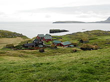
Nólsoyarfjørður

Coordinates: 61 ° 58 ′ 0 ″ N , 6 ° 42 ′ 0 ″ W.

The Nólsoyarfjørður [ ˈnœlsjaɹˌfjøːɹʊɹ ] (Danish name Nolsøfjord ) is a strait in the Faroe Islands between the islands of Streymoy in the west and Nólsoy in the east, after which it is named.
geography
In the south the strait begins at the headland of Kirkubønes on Streymoy and the lighthouse Borðan on Nólsoy. Nólsoyarfjørður is bounded to the north by the northern tip of Nólsoy in the east and Hoyvík in the west.
The strait Skopunarfjørður , which separates Streymoy from the south of the archipelago, flows into the headland of Kirkjubønes . Like this one, the Nólsoyarfjørður is an isogloss of the Faroese language , as Nólsoy has its own dialect.
The Tangafjørður begins north of Nólsoyarfjørður between Streymoy and Eysturoy.
traffic
The Nólsoyarfjørður is the most traveled waterway in the Faroe Islands , as it is located at the port of Tórshavn . Large ships are often at anchor here . The ferry between Tórshavn and Nólsoy runs several times a day via Nólsoyarfjørður .
Swimming competition
Once a year since 1997 the 4 km wide Nólsoyarfjørður has been swum by some Faroese on the occasion of the Ovastevna . They want to keep Ove Joensen's legacy alive and raise money for a swimming pool on Nólsoy.
The record is from 2004 and is 1 hour 17 minutes.
Individual evidence
- ↑ portal.fo : Svimja um Nólsoyarfjørð ( page no longer available , search in web archives ) Info: The link was automatically marked as defective. Please check the link according to the instructions and then remove this notice. (“They swim across the Nolsöfjord”), July 31, 2007
