Tangafjørður

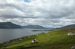
View from Nes (Eysturoy) over Tangafjørður. The flat headland Raktangi can be seen in the center of the picture , and Skálafjørður branches off to the right .
The Tangafjørður [ taŋgaˌfjøːɹʊɹ ] (literally "promontory Fjord", Danish name Tange Fjord ) is a strait of the Faroe Islands between the islands of Streymoy in the west and Eysturoy in the east.
The Tangafjørður begins in the south at the line Hvítanes the west and Nes (Eysturoy) in the east and extends to Kollafjørður the west and Morskranes the east. The northern extension of the water is called Sundini . The Nólsoyarfjørður , the strait between Tórshavn and Nólsoy, begins further south .
Behind Nes, Skálafjørður, the largest fjord in the Faroe Islands , branches off to the north. At the mouth there is the flat headland Raktangi , which gave Tangafjørður its name.
Coordinates: 62 ° 5 ′ 10 ″ N , 6 ° 47 ′ 20 ″ W.