
Tórshavn Havn
| Tórshavn Havn | |||
|---|---|---|---|
| Data | |||
| operator | Port of Torshavn | ||
| Total area of the port | 200,000 m² | ||
| Goods handled | Bulk goods , containers etc. | ||
| Throughput | 500,000 tons of goods | ||
| website | Portoftorshavn.fo | ||
| Geographic information | |||
| place | Tórshavn | ||
| Equal nation within the Kingdom of Denmark | Faroe Islands | ||
| Country | Faroe Islands | ||
 |
|||
| Coordinates | 62 ° 0 '22 " N , 6 ° 46' 11" W | ||
|
|||

The Tórshavn Havn , the Port of Torshavn , is the largest trading and ferry port of the Faroe Islands . 500,000 tons of goods are handled here every year. The Faroese usually only call their capital Havn ("harbor"). So it is the port of the country.
The port of Tórshavn covers an area of around 200,000 m². The berths have a total length of 1,575 m and the maximum depth of the harbor is 9.3 m. The shore along the quays is about 2 kilometers long and a popular walk not only among tourists.
The harbor basin is divided into two areas by the Tinganes peninsula :
- Eystaravág (east bay) is the ferry and trading port. The large ferries (including Norröna and Smyril ) and freighters dock here . This is also where all the overland buses from Strandfaraskip Landsins leave. The Skansin fortress with its lighthouse towers over this part .
- Vestaravág (West Bay) is the fishing port . Here you will not only find the most idyllic photo opportunities, but also the shipyard. However, it is not the largest fishing port in the Faroe Islands. This is located in Klaksvík .
Originally, Tórshavn was not seen as a particularly cheap natural harbor , although the offshore island of Nólsoy has a not unimportant breakwater function. Thus, a thousand years ago, Tórshavn was only important because of its Althing on Tinganes , which was established here because of its geographically central location. But merchants also settled through this political center since the 13th century . The fork period is known from the 17th century. The actual development into a maritime trading hub only happened in the second half of the 18th century through Rybergs Handel .
It was only with the construction of the pier in 1927, however, that Tórshavn became a real seaport that met the increased requirements. At the end of the 20th century this pier was enlarged considerably. The port is an important employer in the capital.
To ólavsøka of Tórshavn harbor every year venue is the largest Faroese rowing competition where the national champion is determined in several classes of the season.
Three webcams make it possible to observe the port live all over the world.

Vestaravág, the western port 1864

Vestaravág in February 2005
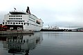
Eystaravág with the two large car ferries Norröna II and Smyril IV.


Web links
- Portoftorshavn.fo (Official website of the port. In English)
- Skipalistin.fo - Ship list of the Faroe Islands (also in English. Extended search for homeport Tórshavn possible)