Well Gruagaichean
| Well Gruagaichean | ||
|---|---|---|
|
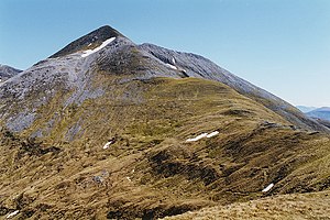
View from the northwest to the summit |
||
| height | 1056 m ASL | |
| location | Highlands , Scotland | |
| Mountains | Grampian Mountains | |
| Notch height | 98 m | |
| Coordinates | 56 ° 44 '37 " N , 4 ° 56' 24" W | |
|
|
||
The Na Gruagaichean is a Munro classified, 1056 meter high mountain in Scotland . Its Gaelic name can be roughly translated as The Virgins .
It is located in the Council Area Highland in the southeast of Fort William and Ben Nevis mountain range of the Mamores , the third highest Munro of which it is. The main chain of the Mamores extends in an east-west direction between the Glen Nevis and the southern village of Kinlochleven and has a total of eight Munros. Two more Munros are a bit off to the east of the main chain.

The Na Gruagaichean lies in the south-eastern part of the Mamores and along the main ridge of the mountain range. It has two distinctive summit pyramids, the north-west summit is slightly lower than the south-east summit at 1041 meters. Both are separated by a small saddle about 1000 meters high, like most of the Mamores peaks, they are stony to rocky and steeply sloping in the summit area. From the south-east summit the main ridge runs again in a north-easterly direction, over the narrow and partly rocky ridge there is a transition to the neighboring Binnein Mòr , the highest peak of the Mamores , via an approximately 960 meter high saddle and a 1062 meter high intermediate summit. From the north-west summit, the main ridge descends to a Bealach located at 783 meters above sea level, while the neighboring 981-meter-high Munro Stob Coire a 'Chàirn joins to the northwest . The Na Gruagaichean also has a nearly one kilometer long south ridge that ends in the 880 meter high Leachd na h-Aire and with its steep slopes towers over Kinlochleven.
Many Munro excavators combine an ascent of Na Gruagaichean with that of the neighboring Binnein Mòr. The starting point is Kinlochleven, from there the path first leads over a public footpath towards Spean Bridge and Corrour Station . Above Loch Eilde Mòr a steep ascent leads over the south ridge of the Sgor Eilde Beag to this pre-summit of the Binnein Mòr, from there over an unnamed pre-summit where the main ridge is reached. From there the path leads over the narrow main ridge to the southwest to the summit of Na Gruagaichean. There are other access options via the main ridge from the north-west as well as via the steep south-west slopes and further over the south ridge.
Web links
- The Na Gruagaichean on munromagic.com (English)
- The Na Gruagaichean on walkhighlands.co.uk (English)
- Hill Bagging - the online version of the Database of British and Irish Hills: Na Gruagaichean (English)
Individual evidence
- ↑ Na Gruagaichean on www.munromagic.com , accessed July 3, 2020


