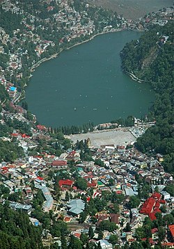
Nainital
| Nainital | ||
|---|---|---|
|
|
||
| State : |
|
|
| State : | Uttarakhand | |
| District : | Nainital | |
| Location : | 29 ° 24 ' N , 79 ° 27' E | |
| Height : | 2084 m | |
| Residents : | 41,377 (2011) | |
| view on the city | ||
Nainital , also called Naini Tal , is a small town in the Indian state of Uttarakhand . Nainital is located in the foothills of the Kumaon region in the Himalayas , 285 km from the state capital Dehradun and 345 km from New Delhi , the capital of India. With a height of over 2000 meters, it is one of the highest cities in the country.
The city is the capital of the Nainital district . Nainital has the status of a Nagar Palika Parishad . The city is divided into 13 wards . On the cut-off date of the 2011 census it had a total of 41,377 inhabitants, of which 21,648 were men and 19,729 women. Hindus make up the largest group of the city's population with a share of approx. 86%, followed by Muslims with approx. 12%. The literacy rate in 2011 was 92.93%.
Nainital is the judicial capital of Uttarakhand, because this is where the state's supreme court is located. The governor of Uttarakhand also has his seat here.
history
The British made a decisive contribution to the development of the city in the second half of the 19th century. During the British colonial period, the city was the summer capital of the United Provinces of Agra and Oudh , which existed from 1902 to 1947. The city thus fulfilled an important administrative function and was home to many British officials. Various English-speaking schools that were founded at that time still bear witness to this time.
sons and daughters of the town
- Jim Corbett (1875–1955), British hunter and conservationist
- Percy Hobart (1885–1957), British officer
- Hastings Ismay, 1st Baron Ismay (1887–1965), British general, politician and diplomat
- Orde Wingate (1903-1944), British general
- Rajeshwar Dayal (1909-1999), diplomat
- Sudhir Kakar (* 1938), psychoanalyst, scholar and writer
- Rajendra Pachauri (1940–2020), economist and engineer


