Narnaul
| Narnaul | ||
|---|---|---|
|
|
||
| State : |
|
|
| State : | Haryana | |
| District : | Mahendragarh | |
| Sub-district : | Narnaul | |
| Location : | 28 ° 3 ' N , 76 ° 6' E | |
| Height : | 311 m | |
| Area : | 14.2 km² | |
| Residents : | 74,581 (2011) | |
| Population density : | 5252 inhabitants / km² | |
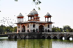
| Jal Mahal in Narnaul | ||
Narnaul is a city (Municipal Council) in the Indian state of Haryana .
Narnaul is located 125 km west-southwest of the federal capital New Delhi at an altitude of 311 m . The city is the administrative seat of the Mahendragarh district .
Narnaul had 74,581 inhabitants at the 2011 census. 97% of the population are Hindus . The urban area is divided into 23 wards .
Web links
Commons : Narnaul - collection of images, videos and audio files
Individual evidence
- ↑ census2011.co.in
- ↑ Directorate of Urban Local Bodies, Haryana ( Memento of the original dated May 30, 2016 in the Internet Archive ) Info: The archive link was inserted automatically and has not yet been checked. Please check the original and archive link according to the instructions and then remove this notice.
- ↑ a b c census2011.co.in

