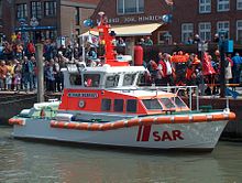
Neuharlingersiel harbor
The port of Neuharlingersiel is a fishing , sport boat and ferry port in Neuharlingersiel .
location
The Neuharlingersieler Hafen is the outlet of a sewer and port at the same time. Seen from the sea side, the port can be reached via a fairway approximately one nautical mile long. There is a groyne next to the fairway to prevent the fairway from silting up. The groyne is flooded at high tide.
history
The port of Neuharlingersiel is an old fishing port. Since 1792 there has been a regular ferry connection to the North Sea island of Spiekeroog , which is about four nautical miles from Neuharlingersiel.
Today's meaning
Today the port is mainly used as a ferry port for trips to Spiekeroog. The ferries Spiekeroog I , II and IV provide the transport connection to the port of Spiekeroog . In addition, there are still numerous fishing cutters in the harbor today. There is also a small marina for sports boats.
Sea rescue
The rescue boat Neuharlingersiel is stationed in the harbor . Sea rescue cruisers and lifeboats in the area of the East Frisian Islands are traditionally stationed on the islands themselves, for example on Borkum, Juist or Norderney. However, until 1981 the island of Spiekeroog did not have its own port, only a pier . Therefore it was stationed in the nearby port of Neuharlingersiel.
See also
Web links
Coordinates: 53 ° 42 ′ 5.8 " N , 7 ° 42 ′ 18.8" E


