Newtown Creek
| Newtown Creek | ||
|
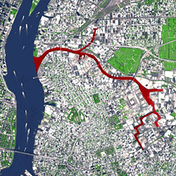
Newtown Creek (marked in red) |
||
| Data | ||
| Water code | US : 958535 | |
| location | New York City , United States | |
| River system | Newtown Creek | |
| source | at the north end of Scott Avenue and Onderdonk Avenue 40 ° 42 ′ 51 ″ N , 73 ° 55 ′ 28 ″ W |
|
| muzzle | on the border of Kings , Queens and New York Counties in the East River Coordinates: 40 ° 44 ′ 10 ″ N , 73 ° 57 ′ 46 ″ W 40 ° 44 ′ 10 ″ N , 73 ° 57 ′ 46 ″ W
|
|
| length | 6 km | |
| Left tributaries | English kills | |
| Right tributaries | Dutch kills | |
The Newtown Creek is a six kilometer long estuary , which forms part of the border between Brooklyn and Queens in New York City , New York forms. One of the environmental problems is oil pollution of the water.
bridges
Bridges include the Pulaski Bridge , JJ Byrne Memorial Bridge, and Kosciuszko Bridge .
Individual evidence
- ^ Mireya Navarro: Between Queens and Brooklyn. To Oil Spill's Legacy . In: New York Times, August 3, 2010.
Web links
Commons : Newtown Creek - Collection of Images, Videos, and Audio Files
