
Ngong Ping 360


Ngong Ping 360 ( Chinese 昂坪 360 , Pinyin Ángpíng Sānliùlíng , Jyutping Ngong 5 ping 4 Saam 1 luk 6 ling 4 ) is the name of a cable car in Hong Kong that connects the Tung Chung district on the north coast of Lantau Island with the Ngong Ping Plateau ( 昂坪 ), on which the Tian Tan Buddha, also known as the Big Buddha , and the Po Lin Monastery ( 寶蓮 禪寺 / 宝莲 禅寺 , also 寶蓮寺 / 宝莲寺 ) and a number of other tourist attractions in Ngong Ping are located Village ( 昂坪 旅遊 村 / 昂坪 旅游 村 ).
The Tung Chung Cable Car Terminal , or “Tung Chung Terminal” for short ( 東涌 „站 / 东涌 缆车 站 -“ Tung Chung Cable Car Station ”), located at the entrance to Hong Kong International Airport , is in the immediate vicinity of the Tung Chung Station of Mass Transit Railway , or MTR for short, is connected to the Hong Kong subway system.
The gondola , Ngong Ping Cable Car ( 昂坪 纜車 / 昂坪 缆车 ), formerly Ngong Ping Skyrail , offers a 5.7 km, 25-minute ride over Tung Chung Bay ( 東涌 灣 / 东涌 湾 ) and the large mountainous nature park in the center of Lantau Island to the Ngong Ping Village and the great Buddha. As an alternative, the ascent can be chosen on foot (approx. 2-4 hours, depending on the route) or a bus or car journey lasting more than an hour via a detour via Tung Chung Road ( 東涌 道 / 东涌 道 ).
prehistory

Lantau Island was largely untouched and very rural until the 1990s because it was only accessible by ship. With the construction of Chek Lap Kok Airport , train and road connections as well as the so-called “ Big Buddha ” and the Buddhist monastery Po Lin were built, which soon attracted so many tourists that the only road connection, Tung Chung Road, could no longer handle the traffic . The Hong Kong government was therefore looking for an alternative to promote Hong Kong's reputation as a tourist destination. After a feasibility study and numerous discussions, a 2S gondola was chosen that has a single drive in the angular station on the airport island and only five supports, another angular station and the end station in the area of the nature park and thus has the least ecological impact on the nature park exercises. In 2003 Leitner ropeways® received the order for the construction of the system, which began in April 2004 and lasted more than two years. Significant difficulties had to be overcome, such as very frequent rainfalls and storms, long-lasting fog and extremely high humidity. Construction roads were not allowed to be laid in the nature park, but since the cargo helicopter could often not fly, a large part of the material had to be brought with mules into the mountains, which rose to 528 m. The cable car opened on September 18, 2006. Disputes with the original operator - among other things because of a gondola crash on July 11, 2007 and the subsequent six-month business interruption - led the Hong Kong subway operator, the MTR Corporation, to also operate the cable car through a subsidiary established for this purpose took over Ngon Ping 360 Ltd.
The cableway


The 2S-Bahn consists of two sections, namely the short 610 m long section from the “Tung Chung Terminal” ( 東涌 站 / 东涌 站 ) to the first corner station on the edge of the airport - “Airport Island” ( 機場 島 站 / 机场 岛)站 , English Airport Iceland Angle station ), and the 5175-meter-long section from there to the terminus "Ngon Ping" ( 昂坪站 ). They each have a 71 mm thick suspension cable and a 42 mm thick circumferential pulling cable that moves the 111 cabins with 17 seats. The cable car starts at the "Tung Chung Terminal" located 21 m above sea level and runs parallel to Chek Lap Kok South Road ( 赤 鱲 角 南路 ) over two supports on both sides of the Sea Channel to the opposite, 32 m high angle station on the edge of the airport. It is a technical station that contains the drives for both sections and through which the gondolas pass without stopping during normal operation. The cable car now bends about 60 ° to the south and is raised enough by a support directly behind the station to hover over Tung Chung Bay to the next support, which is 310 m high, at a distance of 1.5 km. There is a wide view over the airport and the skyscrapers of Tung Chung on one side and over the slopes of the national park on the other. Above the sea, a rope with balls runs parallel to the gondola to warn planes. The cable car travels over two additional supports to the "Nei Lak Shan" ( 彌勒 山 站 / 弥勒 山 站 , English Nei Lak Shan Angle Station ), the highest point of the journey at 560 m. This station also only serves to change direction by 20 ° and is also passed through without stopping. Over the last 1.6 km and two pillars, the train travels on a slight slope with a view of the great Buddha to the terminus Ngon Ping at 438 m above sea level.
The cable car travels at a speed of up to 7.5 m / s (27 km / h) and has a capacity of 4000 people / h in both directions if the staff ensures that not only the 10 seats, but also the 7 standing places in the cabins are filled. The “Diamond 17” cabs were supplied by Sigma . The cabins have vents just above the floor and under the roof to ensure adequate natural ventilation. The loudspeakers for announcements by the management are operated by solar panels on the roof. There is also a “Crystal Cabin” with a glass floor. Due to the great demand, 36 Crystal Cabins with glass bottoms are now in use. There is also a luxury cabin decorated with Swarovski stones with velvet sofas and a bar table for special occasions. When the train is not in operation, the cabins can be parked using an inclined hanging rail in the basement of the "Tung Chung Terminal". There is also a gondola garage at the terminus. The suspension ropes are firmly mounted on both sides. The tension ropes are hydraulically tensioned in the two end stations. The ropes were manufactured by the Swiss company Fatzer AG .
For the evacuation of passengers in emergencies, two rescue cabins are attached to the very wide supports immediately above Tung Chung Bay and shortly before the terminus, which are placed on the pull rope and can drive next to or under the passenger cabins with their own drive.
- Ngong Ping 360 Cable Car system
Tung Chung Terminal , 2008

Airport angle station, 2018

Nei Lak Shan angular station, 2012

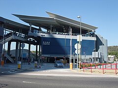
Ngong Ping Cable Car Terminal, 2013


.jpg)

Incidents (selection)
- On June 11, 2007, an unoccupied gondola fell over 50 m during a test drive after closing time near the Tung Chung Bus Terminal . There was no personal injury. The operation of the railway had to be stopped for six months.
- On January 25, 2012 there was a shutdown during operation due to strong vibrations. The cause was found to be bearing damage due to insufficient lubrication in a sheave. The runway, which was occupied by 800 people, was emptied after two hours. After completing the necessary repair and overhaul work, the railway was able to resume operations on April 5, 2012 after a two-month break.
Web links
- Official website (Chinese, English)
- Official Description - Hong Kong Tourism Board (Chinese, English)
- Official Website - MTR Tourist Service (Chinese, English)
- Official Website - MTR-Itinerary Planner - Tickets and MTR line travel planner (Chinese, English)
- Official Website - HK Transport Department - Traffic Info - HK e-Traffic App (Chinese, English)
- Detailed presentation with numerous photos (French)
- Location map Ngong Ping 360 (Chinese, English)
Individual evidence
- ↑ a b Sahil Nagpal: Hong Kong cable car reopens after 100 passengers left stranded - Report on the downtime at Ngong Ping 360 and takeover of the service previously operated by an Australian company by the MTR Corporation in Hong Kong. In: topnews.in. April 12, 2008, accessed November 12, 2019 .
- ↑ Abstract of Expert Panel's Report - Cabin Falling Incident occurred on June 11, 2007 at the Ngong Ping Ropeway - Summary of the investigation report of the Electrical and Mechanical Services Department of Hong Kong on the incident on June 11, 2007. ( pdf ; 835kB) In: www.emsd .gov.hk. January 1, 2007, accessed November 12, 2019 .
- ^ Investigation report of the Electrical and Mechanical Services Department of Hong Kong from April 3, 2012 ( Memento from May 10, 2013 in the Internet Archive ). In: www.emsd.gov.hk, accessed November 12, 2019 ( pdf ; 904kB, English)
- ↑ Press release of the operator NP360 from April 3, 2012. ( pdf ; 137kB) In: www.np360.com.hk. April 3, 2012, accessed November 12, 2019 .
Coordinates: 22 ° 17 '24.9 " N , 113 ° 56' 18.3" E