
Nidelva (Agder)
| Nidelva | ||
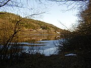
 Nidelva in Blakstad |
||
| Data | ||
| Water code | NO : 019.Z | |
| location | Aust-Agder ( Norway ) | |
| River system | Arendalsvassdraget | |
| origin | Confluence of the Nisserelva and Fyreselv rivers 58 ° 48 ′ 12 ″ N , 8 ° 30 ′ 16 ″ E |
|
| muzzle | in three arms near Arendal in the Skagerrak Coordinates: 58 ° 24 '59 " N , 8 ° 44' 25" E 58 ° 24 '59 " N , 8 ° 44' 25" E |
|
| Mouth height |
0 m
|
|
| length | 210 km (with tributaries) | |
| Catchment area | 4015 km² | |
| Drain |
MQ |
110 m³ / s |
The Nidelva is a river in southern Norway . It gets its name at the confluence of the Nisserelva and Fyreselv and forms the main river of the Arendalsvassdrag , which with a catchment area of 4015 km² discharges water masses of 110 m³ / s on an annual average. From the mouth at Arendal in Agder , where the river flows in three arms into the Skagerrak , to the most distant origins of its source rivers, the water is 210 km long.
With 15 hydropower plants, the entire river system is one of the most heavily regulated bodies of water in Norway. The highest measured discharge at the Rygene power station was approx. 1200 m³ / s during a flood in October 1987. However, there is a stone in Reiersøl ( Froland municipality ) on which much higher water levels from the years 1860, 1892 and 1916 are carved.
The last 22 kilometers of the river the Nidelva carries salmon . Since there are no reproducing salmon in the river, liming, cultivation and fish ladders are planned.

Historical water levels of the Nidelva
Nidelva in Reiersøl
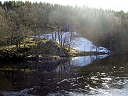
The river squeezes through a narrow place a few kilometers from its mouth


