Nikiforos Fokas
|
Nikiforos Fokas Parish Δημοτική Ενότητα Νικηφόρου Φωκά (Νικηφόρος Φωκάς) |
||
|---|---|---|
|
|
||
| Basic data | ||
| State : |
|
|
| Region : |
Crete
|
|
| Regional District : | Rethymno | |
| Municipality : | Rethymno | |
| Geographic coordinates : | 35 ° 18 ' N , 24 ° 24' E | |
| Height above d. M .: | 196 m (average) |
|
| Area : | 95.641 km² | |
| Residents : | 8,911 (2011) | |
| Population density : | 93.2 inhabitants / km² | |
| Code No .: | 730104 | |
| Structure: |
1 city district 13 local communities |
|
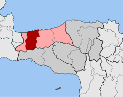
| Location in the municipality of Rethymno and in the Rethymno regional district | ||
Nikiforos Fokas ( Greek Νικηφόρος Φωκάς ( m. Sg. )) Is a municipality in the Cretan city of Rethymno . It was formed in 1997 from the amalgamation of 14 communities around the small town of Atsipopoulo as an independent community and named after the Byzantine emperor Nikephoros II , who conquered Crete from the Arabs in the 10th century. In the course of the Greek administrative reform in 2010 , Nikiforos Fokas was absorbed into the municipality of Rethymno and received the status of a municipality.
For a further breakdown see Rethymno # community structure and population .
Individual evidence
- ↑ Results of the 2011 census at the National Statistical Service of Greece (ΕΣΥΕ) ( Memento from June 27, 2015 in the Internet Archive ) (Excel document, 2.6 MB)
- ↑ Documentation of the community history on eetaa.gr ( Memento of the original from April 29, 2014 in the Internet Archive ) Info: The archive link was inserted automatically and has not yet been checked. Please check the original and archive link according to the instructions and then remove this notice. (Greek)

