Nizki Island
| Nizki Island | ||
|---|---|---|
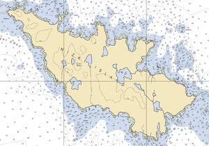
| Map of Nizki Island | ||
| Waters | North pacific | |
| Archipelago | Semichi Islands ( Near Islands ) | |
| Geographical location | 52 ° 43 '59 " N , 173 ° 58' 59" E | |
|
|
||
| length | 5 km | |
| Highest elevation | Jones 51 m |
|
| Residents | uninhabited | |
| Map of the West Aleutian Islands / 4 - Nizki Island | ||
Nizki Island is a 5 km long island in the middle of the Semichi Islands , a subgroup of the Near Islands in the far west of the Alëuten in Alaska . In the west of the island is Alaid Island , from which it is separated by a sandbar. To the east is Shemya Island with the small islands of Hammerhead Island and Lotus Island , from which it is separated by the Shemya Pass strait.
The name comes from Russian and means "flat", which describes the topography of the island well, because the highest peaks of the island are Jones with a height of 51 m and Jack with 47 m.
In Nizki Iceland and the adjacent Alaid Iceland breed again about 1000 pairs of the previously nearly extinct Aleutian Canada goose ( Branta hutchinsii leucopareia ), a subspecies of the dwarf Canada goose .


