
Nonnenberg (Flensburg)
| Nonnenberg Margarethenberg | |||
|---|---|---|---|
 The Nonnenberg with the boundary stone 44 in 2015 |
|||
|
|||
| Coordinates | 54 ° 46 '55.8 " N , 9 ° 21' 46.2" E | ||
| place | Flensburg, Schleswig-Holstein , Germany | ||
| Sprockhoff no. | - | ||

The Nonnenberg (also: Margarethenberg) is a Bronze Age burial mound on which a border stone of Flensburg stands. It is located north of Schäferhaus in the Friesischer Berg district .
history
From the Bronze Age to the 18th century
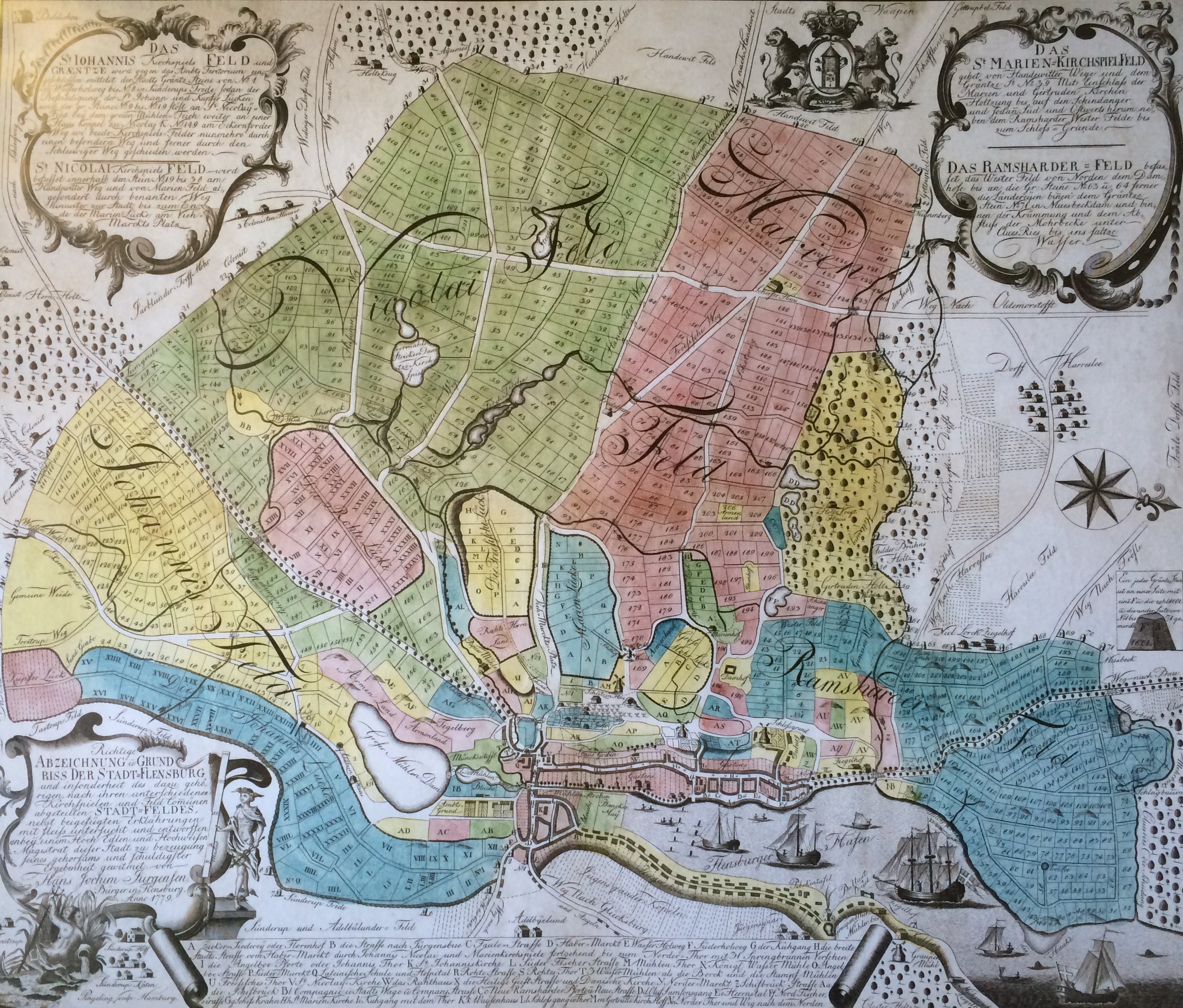
The Bronze Age burial mound is located in the middle of a wall that runs from west to east and which marks the border to Harrislee . It is unclear when this “city boundary wall” was raised. The boundary stone of Flensburg was built in 1601 on the approximately 3.50 meter high hill. The name "Nonnenberg" for the burial mound has been attested since 1768 on the basis of a city map that was created at that time. A later attested name variant is "Nunnenberg", from the year 1779. The name of the hill could indicate nuns . It is not known whether nuns worked in the local area at all. The Franciscan monastery of St. Katharinen existed in Flensburg . To the east of Flensburg, near today's Glücksburg, was the Cistercian Rüde monastery . The reason for the naming of the burial mound is therefore unclear. The city map from 1768 (as well as the city map from 1779) names the stone standing on the hill as boundary stone number 44.
Excavation 1958
Since the Nonnenberg seemed to be endangered by the newly established military training area, and digging work was expected, its hill formation was examined more closely in 1958. Four graves made of stone piles were discovered in the ground. In grave 1 under the core mound there was a well-preserved wooden coffin. There were no traces of corpses to be seen. The grave had been looted and therefore no longer contained any grave goods. Grave 2, south of Grave 1, was a double grave that had also been looted. A bronze dagger was found there. There were no more traces of the corpses. In grave 3, which was also previously looted and located south of grave 2, a gray, smeary layer of earth was still visible, which indicated the corpse. In the earth ransacked by the looters were a fragment of a twisted bronze brooch, a bronze needle and a small curved gold ring . Grave 4 was north of grave 1 in the hill. After removing the upper stone layers, a wooden coffin was discovered, some of which was still solid. Bones from the corpse were still scattered outside the coffin. There were no grave goods to be found, and the grave had also been looted. During further investigations, however, it was found that another grave with a tree coffin was hidden under this grave. In this was a mop of hair with a gold wire spiral, an amber spiral and a bronze dagger.
Individual evidence
- ↑ It is not to be confused with the "Margarethenberg" near Bordelum on the North Frisian North Sea coast .
- ↑ The border between Flensburg and Harrislee can be seen on various city maps.
- ↑ Jakob Röschmann: Prehistory of the Flensburg district . The prehistoric and early historical monuments and finds in Schleswig-Holstein, Volume 6. Neumünster 1963, page 185
- ↑ Flensburg street names . Society for Flensburg City History, Flensburg 2005, ISBN 3-925856-50-1 , article: Jungfernstieg
- ↑ Flensburg Atlas , Flensburg 1978, map No. 10; The aforementioned map 10 from 1768 shows similarities to map no. 11 from 1779. For the more detailed map from 1779 cf. there: Map of Flensburg and the surrounding area 1779 , accessed on: February 4, 2018
- ↑ Flensburg street names . Society for Flensburg City History, Flensburg 2005, ISBN 3-925856-50-1 , article: Jungfernstieg
- ↑ Map of Flensburg and the surrounding area 1779 , accessed on: February 4, 2018
- ↑ In Low German , “Nonn” and “Nunn” correspond to the High German word “ nun ”. See Johannes Sass : The new Sass - Low German Dictionary - Low German - High German, High German - Low German. 2nd edition, Wachholtz Verlag, Neumünster 2002
- ↑ Flensburg street names . Society for Flensburg City History, Flensburg 2005, ISBN 3-925856-50-1 , article: Jungfernstieg
- ↑ See Flensburg street names . Society for Flensburg City History, Flensburg 2005, ISBN 3-925856-50-1 , article: Jungfernstieg
- ↑ In Low German , “None” can also mean nap, similar to the English “noon”, which is known to mean “noon”. see. Langenscheidt . Lilliput Low German. Berlin and Munich 2000
- ↑ Flensburg street names . Society for Flensburg City History, Flensburg 2005, ISBN 3-925856-50-1 , article: Jungfernstieg
- ↑ Flensburger Stadtgeschichte e. V. (ed.): Experience history. A discovery tour along Flensburg's old boundary stones , from December 1, 2012; The GPS coordinates of the poster are obviously incorrect or do not correspond to the general standard. The boundary stones cannot be determined according to the coordinates given there. The boundary stone 44 is indicated, for example, with the coordinate “GPS 3523426/60725600”.
- ↑ Jakob Röschmann : Prehistory of the Flensburg district . The prehistoric and early historical monuments and finds in Schleswig-Holstein, Volume 6. Neumünster 1963, page 185 ff.