Norrbölesån
| Norrbölesån | ||
|
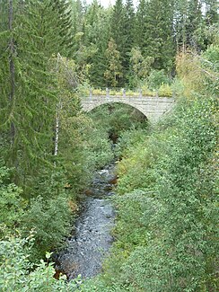
Old bridge over the Norrbölesån |
||
| Data | ||
| location | Örnsköldsvik municipality | |
| River system | Moälven | |
| Drain over | Moälven → Gulf of Bothnia | |
| source |
Tjärnbodtjärnen 63 ° 30 '41 " N , 18 ° 12' 29" O |
|
| Source height | 161 m above sea level | |
| muzzle | in Anundsjösjön near Norrböle Coordinates: 63 ° 26 '16 " N , 18 ° 15' 46" E 63 ° 26 '16 " N , 18 ° 15' 46" E |
|
| Mouth height | 49 m ö.h. | |
| Height difference | 112 m | |
| Bottom slope | 12 ‰ | |
| length | 9 km | |
| Flowing lakes | Mjösjön | |
| Communities | Örnsköldsvik | |
The Norrbölesån is a river in the municipality of Örnsköldsvik , in the Swedish province of Västernorrlands län . It rises in Tjärnbodtjärnen and flows from there in a southerly direction to Norrböle, halfway through the Mjösjön lies in a swamp area. After nine kilometers, the Norrbölesån flows into the Anundsjösjön with a small delta .
Web links
Commons : Norrbölesån - collection of images, videos and audio files
Individual evidence
- ↑ a b c d Stenbäcken, EU CD: SE704192-162201. VattenInformationsSystem Sverige, accessed December 5, 2012 (Swedish).
