
Moälven
|
Moälven Själevadsån |
||
 Map of the Moälven river system |
||
| Data | ||
| location | Västerbottens län , Västernorrlands län ( Sweden ) | |
| River system | Moälven | |
| River basin district | Bottenhavet | |
| source |
Över-Karpsjön 63 ° 54 ′ 35 ″ N , 17 ° 40 ′ 28 ″ E |
|
| Source height | 430 m above sea level | |
| muzzle | at Domsjö in the Gulf of Bothnia coordinates: 63 ° 15 ′ 46 " N , 18 ° 42 ′ 53" E 63 ° 15 ′ 46 " N , 18 ° 42 ′ 53" E |
|
| Mouth height | 0 m o.h. | |
| Height difference | 430 m | |
| Bottom slope | 12 ‰ | |
| length | 35 km with Norra Anundsjöån 135 km |
|
| Catchment area | 2,307.2 km² | |
| Drainage at the Domsjö gauge |
NNQ (March 1996) HHQ (May 1989) |
3 m³ / s 146.9 m³ / s |
| Drain |
MNQ MHQ |
5 m³ / s 165 m³ / s |
| Left tributaries | Norrbölesån , Forsån | |
| Right tributaries | Galasjöån , Kallån | |
| Flowing lakes | Anundsjösjön , Happstafjärden , Själevadsfjärden , Veckefjärden | |
| Medium-sized cities | Örnsköldsvik | |
| Communities | Åsele , Örnsköldsvik | |
| Navigable | 20 km (small motorboat ) 45 km ( canoe ) |
|
 The Moälven shortly before its mouth in Domsjö. |
||
 Rapids in Moälven |
||
The Moälven [ muːɛlvən ] or Själevadsån is a river in the Swedish landscape of Ångermanland . It is formed from the three source rivers Norra Anundsjöån , Södra Anundsjöån and Utterån . The source rivers arise as streams in moors and small lakes in the municipality of Örnsköldsvik , the longest source stream rises at the foot of the Karpsjökasen in the municipality of Åsele in southern Lapland . The actual Moälven begins in Bredbyn , from there its length is about 35 kilometers. Norra Anundsjöån and Moälven are together about 135 kilometers long. The river flows into the Gulf of Bothnia south of Örnsköldsvik .
Due to its diverse fauna with otters , crayfish and freshwater pearl mussels , the Moälven is particularly protected as a realm of interest and Natura 2000 area. Since a reintroduction project in 2006, salmon have been living in the river again; the former population was extinct in the 1950s.
There was an important timber industry on the Moälven and its source rivers, especially in the 18th and 19th centuries. The rivers were straightened and cleared for rafting , which is partly still visible today. Three hydropower plants were built for sawmills and the paper mill in Domsjö , which are up to 100 years old and still in operation.
etymology
The name Moälven is made up of the prefix Mo and the Swedish word älv , which also means å river. Mo probably comes from Moliden , a village that emerged in the nineteenth century and earlier only Mo said. Mo is probably derived from mon , an old word for the Oser on which the village was built.
Before the village existed, the river was probably called Gena älv ; old names are Genan for Norra Anundsjöån and Anan for Södra Anundsjöån. They come from the word genes that of Geinir derived, in Urnordischen that looked the term for the spaces in fishing nets, by their slightly rounded, oblong shape as bays or straits. It is believed that the fishermen called a strait near the current mouth of the Moälven Gene ; there was an Iron Age settlement known as Gene fornby . It was abandoned when the passage flattened due to the postglacial land elevation . The settlement was right on the left bank of the river, today it is a few hundred meters from the right bank.
The alternative name Själevadsån is rarely used, in contrast to earlier times, when Själevad was more important than the main town of Örnsköldsvik municipality, as the river only flows a short distance through Själevad . The town of Örnsköldsvik was only founded in 1842, and Själevad has had a market place and later a church since early modern times .
geography
The Moälven arises from three source rivers. The Södra Anundsjöån and the Utterån arise in the municipality of Örnsköldsvik , the Norra Anundsjöån in the municipality of Åsele in southern Lapland . At a height of 50 m. The Norra Anundsjöån coming from the northeast and the Södra Anundsjöån coming from the east converge at Anundsjösjön and form the Moälven, south of the lake the Utterån flows. The source rivers of the Moälven are relatively shallow, with some smaller rapids (Swedish fors ) and meanders . Much of the river's catchment area is sparsely populated. In addition to Örnsköldsvik, the only town in the region, there are the larger towns of Bredbyn , Mellansel and Gottne . These have between five hundred and a thousand inhabitants. In addition to Anundsjösjön , the Moälven also flows through three fjärden , the Happstafjärden (sometimes called Haffstafjärden), the Själevadsfjärden and the Veckefjärden and flows into the Örnsköldsviksfjärden bay in Domsjö .
Utterån
The Utterån rises in Stor-Uttersjön , about three kilometers north of Innertällmo . It flows in a south-easterly direction, partly with meandering sections, falls down the Sågfallet and flows into the Moälven at Gottne .
Norra Anundsjöån
The Norra Anundsjöån is the longest of the three source rivers. It rises as Karpsjöbäcken from the Över-Karpsjön at the foot of the Karpsjökasen mountain in southern Lapland , flows through several small lakes and joins the Solbergsån near Solberg ; from there he bears the name Norra Anundsjöån. Between Seltjärn and Kubbe , Norra Anundsjöån has many oxbow lakes . Behind Kubbe, Norra Anundsjöån is dammed up at Kubbe kraftverk, and just before Anundsjösjön it flows into Södra Anundsjöån. Together they form the Moälven.
Södra Anundsjöån
The Södra Anundsjöån rises on the border with the municipality of Sollefteå as Bergsjöån from the Norra Bergsjön . It flows in a south-easterly direction past Gammelgården and from there is called Södra Anundsjöån. In Bredbyn , Södra Anundsjöån and Norra Anundsjöån form the Moälven.
Moälven

Behind the Anundsjösjön, the Moälven flows through the village of Mellansel . Shortly before Gottne, where the Utterån flows into the Moälven, is the Märraforsen. After the Utterån has taken up, the Moälven calms down and flows through Moliden to Gala with Galastan, an old trading post. Until then, one kilometer upstream from the Happstafjärden, the sailing ships and later steamers with passengers and fishing boats used to go. There have been many sawmills on Moälven since the sixteenth century. There was a lot of traffic with tractors that transported tree trunks to the sawmills and, after their processing, for shipping to Domsjö.
Behind Gala the Moälven forms a small delta before flowing through the uppermost of the three fjärden, the Happstafjärden. At Billsta it flows through the Billstasundet, a narrowing between the two lakes. In the Själevadsfjärden there are three small islands, the Prästholmarna, and at its lower end is the place Själevad with the main church Själevads kyrka of the parish of the same name. There has been a market square here since the sixteenth century and later a church was built on a hill by the river. The old church was replaced by a new one in 1880, which was voted Sweden's most beautiful church in 1998. The narrowing of the Moälven between the Själevadsfjärden and the Veckefjärden is called Prästsundet (German Pfarrersund). Since the Middle Ages there has been a bridge to the church downstream from what is today. At the old location, the bridge on European route 4 leads to Örnsköldsvik. When the old bridge in the middle of the nineteenth century was no longer able to cope with the increasing through traffic - especially in spring it was often impassable - and fell into disrepair, the community decided to build a new one, which was built in 1850–51. The municipality had to raise the costs for the new bridge, around 40,000 riksdaler banco , this corresponds to 3.825 million crowns . A request to the king for financial support was refused.

Map of the church and bridge 1701, the location of the bridge at that time is marked in brown, today's location in black.
Old church and bridge in Själevad between 1851 and 1876.
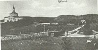
The new church and the old bridge in Själevad between 1876 and 1930

Today's bridge and church in Själevad 2012


At the lower end of Veckefjärden is the Veckedammen weir , which was built in the late 1930s to prevent seawater from entering the fjärde. There the water for the cellulose factory is taken and pumped through Hörnett to Domsjö via a pipeline. There are two locks at Veckedammen ; a small one for pleasure boats, which is controlled remotely from the factory, and the old wooden lock, with a length of 245 meters the longest lock in Sweden. The length was necessary so that tugs with their rafts, often over 100 meters long, could fit in completely. Since the end of rafting in the 1950s, the wooden lock has only been used rarely, it is open in spring and autumn so that the floods of the swelling Moälven are not obstructed. After the weir, the Moälven flows about three kilometers between Domsjö and Hörnett until it flows into Örnsköldsviksfjärden and thus into the Gulf of Bothnia .
geology
The river valleys of the Moälven and its source rivers consist mainly of silt and clay , the surrounding areas of moraines ; the rock in question is granite and gneiss . The deposits formed during and after the Vistula Glaciation , when glacial rivers carried large amounts of material with them and formed deltas and oser that were still visible . The Hällåsen (Oser), the Kubbeåfaltet (Delta) on Norra Anundsjöån and the Bergsjöåsen (Oser) on Södra Anundsjöån are well-preserved evidence of Ice Age activities and of great geological value.
Hydrology

The water catchment area of the Moälven and its source rivers has an area of around 2300 square kilometers. Inland, it consists of much of Örnsköldsvik municipality before narrowing towards the sea. The source rivers of the Moälven are fed by many small streams that arise in moors. In its lower reaches, the river widens into the fjords and has a slow current there . That is why floods practically never occur. Another reason for this is the high storage capacity of the soil in the catchment area; in the case of heavy rainfall, the water is bound in the ground instead of flowing away.
The water quantities in Moälven vary between 10 m 3 / s in winter and summer and over 100 m 3 / s in spring and autumn; After particularly snowy winters, the spring flood in May can reach currents of up to 200 m 3 / s. In winter the Moälven freezes over to the mouth, the ice thickness is on average half a meter. Only at the factory in Domsjö is the water open in winter. The water temperature of the river varies between 0.2 ° C in March and 16 ° C in August.
flora

Only a few plant species thrive in and on the Moälven, as it is relatively poor in nutrients. In the calm, shallow parts of the river there are spawning herbs that swim in the stream like long hair. In the lakes and ponds are yellow water-lily , ranunculus peltatus and cattails before.
The catchment area of the Moälven is very swampy and criss-crossed by smaller watercourses that later merge in the river. The plants are adapted to the wet environment. Birch trees and willows grow on the river banks. B. the almond willow . Plants that get by with few nutrients, such as pine fronds , swamp lice weed and red and yellow foxtail grass are common .
Between the Happstafjärden and the Själevadsfjärden lies the Billaberget , a so-called sydväxtberg , on Moälven. Solar radiation and heat storage in the rock ensure a mild microclimate, which means that species grow on the southern slope for which the northern climate would otherwise be too harsh, e.g. B. the Vosges rose . There is one of Sweden's northernmost hazelnut populations, known since the seventeenth century.
The Krokmyrliden , a moor about eight kilometers north of Mellansel , is a biological specialty. The rock in Ångermanland consists largely of gneiss and granite , and plants that are adapted to acidic environments grow. The soil in the Krokmyrliden, however, is calcareous, which means that plants such as Green Tongue , Winter Horsetail and Mosquito Haendelwurz can be found, which are otherwise extremely rare in Örnsköldsvik municipality.
fauna
In the Moälven there are beavers , otters and many species of fish, including pike, burbot and perch. The rare river pearl mussel is found in the river. There are also relic crabs ; a species of hover shrimp that occurs only in areas where the land was covered with ice during the last ice age. They are food for many fish and a good pH indicator as they are prone to pH levels that are too low . Crayfish were found everywhere in Moälven until 2008, mainly in the lower part. They have since disappeared there. No living or dead animal could be found so that an analysis could clarify whether the cancer plague was responsible for the disappearance.
Salmon

As early as the sixteenth century, salmon were fished on the lower reaches of the Moälven , and the population was able to hold up into the 1950s. Due to the increasing pollution and the straightening of the river for rafting, the salmon and the trout population died out. A project supported by the European Union has been running since 2006 to release salmon again in Moälven . To this end, several old hydropower plants were dismantled and the course of the river renatured. In addition, a fish ladder was built at Sågfallet near Gottne, otherwise the salmon would not be able to overcome this obstacle. The stairs were not built above ground on the side of the river, as is usually the case, but led through an adjacent mountain with blasts. In the upper part of the stairs, the returning salmon swim through a fish counter and are measured there.
Since the salmon in Moälven had become completely extinct, young salmon from the Lögdeälven population were used for the project . This river is similar to the Moälven because it is a smaller forest river; Salmon that live in mountain streams have different habits; they later migrate back to their spawning grounds.
The Atlantic salmon in the Baltic Sea and thus those in Moälven are much lighter in color than those in Norway. This is due to the prey of the fish: In the Baltic Sea, the salmon eat more small fish such as herrings, while the salmon in the North Sea and Northeast Atlantic eat more crustaceans. These give the salmon their typical light pink color.
The EU project is carried out on site by volunteers. They release young salmon in the upper reaches and measure the returnee. There are several pools in the fish ladder that can be closed to get the salmon out. Between 2006 and 2008, a total of 400,000 young salmon and 40,000 trout were released in Moälven; at controls in 2007 these had grown considerably. A year later they migrated to the Baltic Sea and in 2009 the first returnee could be caught. The number of returning salmon counted decreased from 37 in 2012 to 24 in 2014, and the number of trout increased from 47 to 56 fish in the same period. The largest registered specimens in 2014 were a 106 cm long salmon and a 78 cm long trout.
River pearl mussels
In Moälven there is only a small population of old river pearl mussels ; since their larvae live on the gills of salmon and trout, no reproduction has taken place for several decades. Due to the revitalized salmon and trout populations, there is hope that young mussels will be found again in the near future.
The Moälven is basically a good freshwater pearl mussel habitat, as it is relatively low in nutrients, rich in oxygen and largely flat.
Otter

Otters and beavers are relatively common on Moälven; due to the natural course of the river and the low level of development, they can spread unhindered. From 1991 to 2005 the otter population in Örnsköldsvik municipality increased from 6 to 9 specimens in 1991 to 17 to 22 in 2005; otters migrated from the river valleys of the Gideälven and Nätraån to the Moälven. There they have successfully settled and continue to multiply, reducing the risk of the local population becoming extinct.
In order to make it easier for the otters to spread into new habitats, fences were set up and underpasses built on bridges in places where they normally cross paths and run the risk of being run over.
Economic use
In almost every village along the Moälven and its headwaters there used to be water mills and gang saws , but these were often only designed for local consumption. Later larger sawmills were built and the wood was rafted to the coast after processing. Some of the historic mills and saws have been restored, such as the one in Sörflärke .
In Myckling, a district of Själevad, there was the Ångbryggeri Aktiebolag i Själevad company , a brewery, from 1880 . It was founded by Kristian Fredrik Madlung, a German, and the wholesaler Perman from Fränsta . The brewery got its water from Svarttjärnen , which is drained through the Kvarnbäcken to Moälven. Originally only alcoholic beverages were produced, from 1905 mineral and soft drinks were bottled. In 1883 the annual production was 100,000 cans (about 260,000 liters) of beer, due to sales problems in 1970 the company had to file for bankruptcy.
Timber industry


The wood industry has shaped the history of Moälven like no other branch of industry. The first documented sawmill on Moälven was Kronosågen vid Galasjöån from 1573, the boards for the castle buildings of King John III. sawing in central Sweden. However, the sawmill had to stop working again as early as 1600, as the large logs required were in short supply. Probably the most famous sawmill was that in Mo, which was in operation from 1779 to 1894. During its existence it changed hands several times until it was taken over by Johan Carl Kempe from Härnösand in 1836. When Kempe died in 1872, the open trading company Mo Bruksägare was converted into the joint stock company Mo och Domsjö Aktiebolag (MoDo), which is considered the year MoDo was founded. Under Frans Kempe and his successors, the small wood company became one of the largest wood processing industries in Sweden. The sawmill in Mo was shut down in 1894 and production relocated to Norrbyskären .
In Domsjö one began to concentrate on the wood pulp production. In 1903 the Domsjö Fabriker was founded at the mouth of the Moälven and in 1929 the largest wood-based panel factory in Europe was built in Hörnefors . Several systems were built on the company premises at the mouth of the Moälven; In addition to wood products and paper, sulfite fuel was produced. In 1988 MoDo took over the AB Iggesunds Bruk and Holmens Bruk AB , from which the Holmen Group was formed.
rafting
The first documented timber transports on the Moälven were the deliveries of construction timber from Galastan to the castles under construction. Wood was later transported to the coast from the river sawmills, and rafting began in the mid-nineteenth century . Paddle steamers hauled rafts made of tied tree trunks to Happstafjärden and Billstasundet, where they were sorted by size and customer. The wood destined for Domsjö Fabriker was sorted in the fairway, that for other customers on the bank.
fishing
Since the area around the villages Västeralnö and Gala at the upper end of the Happstafjärden has been inhabited, the people there have fished smelt , which swam in large swarms up the Moälven to their spawning grounds every May. At night, when the fish swam in large numbers in the shallow water along the bank, they were caught with nets . In contrast to the southern parts of Sweden, however, the fish were not eaten, but used as animal feed. In the 1920s and 30s, local mink breeders began to take an interest in smelt as a feed; as a result, fishing gained industrial importance. In the mid-1950s, up to 10 tons of smelt were caught per year, but at the end of the decade the fishery ended because of the ever-shrinking population. The decrease is mainly due to the pollution of Moälven and the pump on Själevadsfjärden, which sucked in large quantities of the young fish.
In 1557 the fishermen from the town of Gävle were granted the royal privilege to fish on the Norrland coast. For this, the Gävle fishermen had to hand over every tenth barrel of caught fish to the king. In the lower reaches of the Moälven they had been fishing for salmon since the end of the sixteenth century; the annual catches ranged from a few hundred kilograms to a ton. In the eighteenth century there were eleven bridge-like structures on Moälven, which spanned the river partially or completely and from which salmon were fished. They formed an obstacle to freight traffic and rafting, which increased as industrialization began, and were demolished at the end of the century.
Hydropower

Because of the natural state of the river (only about 15 percent of its capacity for electricity production is expanded, a very low value by Swedish standards) it was declared a Natura 2000 area by the Swedish government in 2002 and excluded from the national plan for the development of hydropower. This means that the Moälven should be specially protected and no new hydropower plants may be built there. There are three hydropower plants , Gottne kraftverk in Moälven, Kubbe kraftverk in Norra Anundsjöån and Sörflärke kraftverk in Södra Anundsjöån. The Gottne kraftverk is passable for migratory fish, the other two form insurmountable obstacles for trout and salmon and are to be provided with fish paths in the future .
| Location | power | mean annual electricity production | Construction year | owner |
|---|---|---|---|---|
| God | 780 kW | 5 GWh | 1921 | Vattenfall Ångermanälven AB |
| Kubbe | 5 MW | 26 GWh | 1953 | Statkraft Sverige AB |
| Sörflärke | 105 kW | 540 MWh | 1914 | Sörflärke Elektriska Förening Upa |
Water quality
Until the beginning of the twentieth century, the Moälven was a very pure river, due to the small population in its catchment area. When factories were built at its mouth, chemical pollution increased. From the 1930s, the factories dumped sewage into the river. These removed the oxygen from the river, so that the living beings suffocated. This was one of the main reasons salmon and trout became extinct in the 1950s. The plant was later modernized with the construction of new clarifiers; today the factories are no longer a threat to fish. For a long time, rafting resulted in toxic phenols from the bark of the tree trunks in the Moälven, leading to a lack of oxygen and dead river bottoms. Since the end of rafting in the 1950s, these substances in the river have been decreasing. As parts of the river banks were built on more and more densely, the pollution with sewage from households increased; today this is prevented by sewage treatment plants on the built-up river sections.
Biological goodness
The biological water quality of the Moälven is very good. Except in the vicinity of factories, it is only slightly polluted (quality class I-II, in the upper reaches of the source rivers even quality class I). The biochemical oxygen demand in the river is between 0.5 and 2.0 milligrams / liter, the depth of view between 1.0 and 1.5 meters. Both testify to good water quality. The high turbidity of 0.8 to 2.4 NTU is due to the fact that the Moälven is formed from many small streams that arise in moors. These carry large amounts of humus with them and color the Moälven dark. Due to the low flow speed in the fjords, these act as settling basins , where the water becomes clearer due to the sedimentation .
The mouth of the Moälven was heavily polluted by the Domsjö factories in the 1970s , where the oxygen content was well below the average in the upper reaches of the river. The biochemical oxygen demand was many times higher than the mean.
Chemical goodness
The chemical quality of Moälven has improved since the 1980s, which is mainly attributed to better sewage treatment plants, less agriculture and lower pollutant emissions. The nutrient content in the river is good to very good, just the Forsan suffers from eutrophication . The phosphorus content in the lower sections of the river fell between 1979 and 2007 from 40 to just under 20 micrograms / liter. The phosphorus content is higher in spring and summer than in autumn. The nitrogen content in the lower sections of the river fell from 600 to 300 micrograms / liter between 1979 and 2007. The pH value in the upper Moälven rose between 1979 and 2007 from 6.2 to 6.7, in the lower river from 6.4 to 6.7. To support the rise in pH, Moälven is regularly limed and there is a lime dispenser at Utterån . The lack of lime in the rock that could act as a neutralizer is the reason for the acidic soil around the river and thus the acidic environment in the Moälven. For the river to be a suitable habitat for salmon, the pH must be at least 6.5.
After the Chernobyl disaster on April 26, 1986, northern Sweden was one of the hardest hit areas. For a while, mushrooms and reindeer meat were highly radioactive. Traces of it are still detectable today; Predatory fish such as pike or perch in particular can contain 137 cesium with a decay rate of up to 1500 Becquerel / kilogram. However, if not consumed excessively, this amount of radiation is insignificant compared to the radiation dose to which every person is exposed through natural radioactivity .

Water structure quality
The natural water structure of the Moälven has largely been preserved, the course was only moderately affected. The course of the river was changed again and again, especially by rafting. The Sågfallet is an example of an unwanted change; often entire stretches of river were straightened, the river bed cleared and small dams built so that the tree trunks could move forward without problems. One of the biggest interventions in the course of the Moälven was the last straightening in the early 1950s, when machines were used on a large scale for the first time. A few years later, in 1958, the Moälven river system was last rafted. Since then, the waters have become closer to nature again, and some sections of the river have been renatured .
Nature conservation on the Moälven

In the catchment area of the Moälven there are three nature reserves (corresponds to the German nature reserves ): parts of the beaches of Veckefjärden , Billaberget and Mossaträsk-Stormyran . Two stretches of beach are protected on Veckefjärden: one at the widening of the Prästsund into the fjärde and the other at its lower end. Partly it is alluvial forest with stocks of hardwoods such as linden and ash . On Billstasundet lies the 230 meter high Billaberget, which, in addition to its hazelnut deposits , is protected due to other rare plant species such as the liverwort, which already blooms in April . The Mossaträsk-Stormyran is a rain moor ten kilometers northwest of Solberg in the interior of the municipality Örnsköldsvik at an altitude of 425 to 460 meters above sea level. The protected area covers an area of nine hundred hectares , is next to the Natura 2000 nature reserve and was included in the Ramsar list . A special feature of the 2002 inventory was a male lemon wagtail and a female yellow wagtail that brooded together and raised young.
The Pengsjökomplexet is a moorland with an area of over four thousand hectares, in which the ecological balance has largely been preserved. Therefore, the moor was declared a national interest and a Natura 2000 area. However, the entire area is unprotected, it belongs to companies such as SCA and Holmen.
The Myckelgensjösjön and its banks are a naturvårdsområde ; The protection of the area is roughly the same as for nature reserves, but the area can still be used. For example, Gammelgården is managed. In the event of an intervention such as a new building, the impact on nature should be as low as possible.
There are several water protection areas along the course of the Moälven and its source rivers from Solberg to Själevad . These are river sections, lakes or wetlands that should be preserved because of their special value. Other protected areas are the Skogliga biotopskyddsområden (roughly equivalent to biotope protection ), these are often small forest areas with particularly large or old trees. The most important protective measure in a Skoglig biotopskyddsområde is the ban on forestry.
Recreational use

There are many opportunities for ornithological observations at the headwaters of the Moälven. Many lakes and wetlands are visited each year by migratory birds, which fly north along the coast in spring and then follow the rivers inland.
Due to its shallow depth, the Moälven is only navigable in the lowest section for around 20 kilometers with smaller motor boats , but with paddle boats or canoes on a much longer stretch of the river. Often, especially when the water is low in summer, you have to avoid smaller rapids on foot and can then continue to follow the river. In Själevad there is the friluftscentralen (outdoor center) where you can rent canoes and paddle boats for a trip on the fjords.
Fishing is allowed almost everywhere on Moälven, with the exception of some protected lakes. The river is divided into several sections, where the fiskevårdsområdesföreningarna ( fishing clubs ) ensure that the waters are in good condition. Children can fish for free, adults have to buy a fishing license .
Due to the often swampy or wooded river banks, hiking is only possible on shorter stretches of the river. Baden you can throughout the river, just at Veckedammen are prohibited. There are sandy beaches at Stor-Åskasjön, Myckelgensjösjön and Anundsjösjön near Norrböle, among others. Since the Moälven freezes over completely in winter, except at the factory, you can go cross-country skiing on it or drive snowmobiles on the frozen fjords. Ice skating is almost never possible as the ice is covered with snow.
The Moälven in art

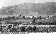
In August Jansson's (1851–1915) picture from 1908, you can see Moälven in the foreground and the Domsjö factories five years after they were founded. At that time the ferry docked below the factory, today's bridge is upstream to the right of the white house.
Axel Andersson (1899–1981), publicist and member of the Reichstag from Örnsköldsvik, wrote the poem Moälven - pulsådern . He describes the river as the pulsating artery of the region around Örnsköldsvik, how it made life possible long before there were paths or roads, and that it still carries hopes for the future with it today.
swell
literature
- Lars-Erik Edlund: Från Gene till Myckelgensjö - kring ett hydronymkomplex i norra Ångermanland. In Nomina Germanica (ed S. Strandberg), Vol. 22, pp. 85-106. Uppsala universitet, Uppsala 1997. ISBN 91-554-4051-7
- Ragnar Holmberg et al. : Vattenundersökning i Moälven 1974–75. Länsstyrelsen i Västernorrlands län, Härnösand 1976.
- Anders Lindström (ed.): Nature guide from Örnsköldsvik, Sweden. Örnsköldsviks kommun, Örnsköldsvik 2000. ISBN 91-972328-1-5
- Anders Nordin et al. : Moälven: båtar Bäumenkor händelser. Själevads hembygdsförening, Själevad 1996.
- Göran Sjöberg: Gideälven, Moälven, Nätraån: inventory of landskapsbild, naturvärden and förutsättningar for rörligt friluftsliv along tre skogsälvar i Örnsköldsviks kommun. Länsstyrelsen i Västernorrlands län, Härnösand 1975.
- Johan Spens, Babette Marklund: Utvärdering av Recipientkontrolle i Örnsköldsviks kommun 1979–2007. Örnsköldsviks kommun: Samhällsbyggnadsförvaltningen (Bygg- och miljöavdelningen), Örnsköldsvik 2012.
- Karl Söderlund: Moälvens dalgång: förutsättningar och utvecklingsidéer turism och friluftsliv. Örnsköldsviks kommun: Kultur- och fritidkontoret, Örnsköldsvik 1995.
- Hjalmar Vallin: Moälven från källorna till havet. Article series in Örnsköldsviks Allehanda, Örnsköldsvik spring 1961.

Web links
- Evert Baudou: Inventering av forntida kustboplatser i Ångermanland år 1966. Fornvännen (PDF, Swedish; 1.7 MB).
- Jan W. Mascher: Nya fynd i Ångermanlands flora. Svensk Botanisk Tidskrift 101: 6 (2007) (PDF, Swedish; 1.6 MB).
- Örnsköldsviks kommuns kulturhistoria - en översikt. Örnsköldsviks kommun (PDF, Swedish).
Footnotes
- ^ Hjalmar Vallin: Moälven från källorna till havet. 1961, p. 5.
- ^ Hjalmar Vallin: Moälven från källorna till havet. 1961, p. 42 f.
- ↑ a b c d e Moälven. (No longer available online.) Örnsköldsviks kommun, formerly in the original ; Retrieved January 8, 2013 (Swedish). ( Page no longer available , search in web archives ) Info: The link was automatically marked as defective. Please check the link according to the instructions and then remove this notice.
- ↑ Län och huvudavrinningsområden i Sverige. (PDF; 2.5 MB) Sveriges Meteorologiska och Hydrologiska Institut (SMHI), accessed on October 20, 2012 (Swedish).
- ↑ Data calculated by the SMHI (not measured), source is Moälven EU_CD: SE702103-164458. VattenInformationsSystem Sverige, accessed January 8, 2013 (Swedish).
- ↑ a b c d Återintroduktion av lax och havsöring. (No longer available online.) Örnsköldsviks kommun, archived from the original on March 4, 2016 ; Retrieved January 8, 2013 (Swedish). Info: The archive link was inserted automatically and has not yet been checked. Please check the original and archive link according to the instructions and then remove this notice.
- ↑ a b c d Flottningsepoken. (No longer available online.) Örnsköldsviks kommun, formerly in the original ; Retrieved January 8, 2013 (Swedish). ( Page no longer available , search in web archives ) Info: The link was automatically marked as defective. Please check the link according to the instructions and then remove this notice.
- ↑ a b Vattenkraftverk. (No longer available online.) Örnsköldsviks kommun, formerly in the original ; Retrieved January 8, 2013 (Swedish). ( Page no longer available , search in web archives ) Info: The link was automatically marked as defective. Please check the link according to the instructions and then remove this notice.
- ↑ Befolkningsutveckling i Nolaskog - Örnsköldsviks kommun. (PDF) (No longer available online.) Hembygds- och Släktforskare Nolaskogs, archived from the original on March 10, 2016 ; Retrieved October 20, 2012 (Swedish). Info: The archive link was inserted automatically and has not yet been checked. Please check the original and archive link according to the instructions and then remove this notice.
- ^ Lars-Erik Edlund: Från Gene till Myckelgensjö - kring ett hydronymkomplex i norra Ångermanland. 1997, p. 85.
- ^ Lars-Erik Edlund: Från Gene till Myckelgensjö - kring ett hydronymkomplex i norra Ångermanland. 1997, p. 86 ff.
- ↑ Due to the uplift of the land, the Moälven was directed into its current bed, which runs further north.
- ↑ a b Nolaskogsbygden i gamla tider. Örnsköldsviks kommun, accessed October 20, 2012 (Swedish).
- ^ Tatorter 1960-2005. (PDF; 590 kB) Statistiska centralbyrån, accessed on October 20, 2012 (Swedish).
- ^ Hjalmar Vallin: Moälven från källorna till havet. 1961, p. 43.
- ↑ Göran Sjöberg: Gideälven, Moälven, Nätraån: inventering av landskapsbild, naturvärden och förutsättningar for rörligt friluftsliv along tre skogsälvar i Örnsköldsviks kommun. 1975, p. 90.
- ↑ a b c Bertil Charlie Wallin: De mindre vattendracht i Västernorrlands län: en naturinventering. 1961, p. 86.
- ^ Bertil Charlie Wallin: De mindre vattendracht i Västernorrlands län: en naturinventering. 1961, p. 68.
- ^ Hjalmar Vallin: Moälven från källorna till havet. 1961, p. 6.
- ^ Bertil Charlie Wallin: De mindre vattendracht i Västernorrlands län: en naturinventering. 1961, p. 68 ff.
- ^ Bertil Charlie Wallin: De mindre vattendracht i Västernorrlands län: en naturinventering. 1961, p. 70.
- ↑ Göran Sjöberg: Gideälven, Moälven, Nätraån: inventering av landskapsbild, naturvärden och förutsättningar for rörligt friluftsliv along tre skogsälvar i Örnsköldsviks kommun. 1975, p. 85.
- ↑ Göran Sjöberg: Gideälven, Moälven, Nätraån: inventering av landskapsbild, naturvärden och förutsättningar for rörligt friluftsliv along tre skogsälvar i Örnsköldsviks kommun. 1975, p. 73 f.
- ↑ Anders Nordin et al. : Moälven: båtar Bäumenkor händelser. 1996, p. 18.
- ↑ Själevads kyrka, Sveriges vackraste 1998. (No longer available online.) Örnsköldsviks Allehanda, archived from the original on July 28, 2013 ; Retrieved October 20, 2012 (Swedish). Info: The archive link was inserted automatically and has not yet been checked. Please check the original and archive link according to the instructions and then remove this notice.
- ↑ Anders Nordin et al. : Moälven: båtar Bäumenkor händelser. 1996, p. 120.
- ↑ All in all: SCB: s första 150 år. (PDF; 29.4 MB) Statistiska centralbyrån, accessed on October 20, 2012 (Swedish).
- ↑ Anders Nordin et al. : Moälven: båtar Bäumenkor händelser. 1996, p. 119 f.
- ↑ Svedjeholmen's canal. (No longer available online.) Bosse Arnholm, formerly in the original ; Retrieved October 20, 2012 (Swedish). ( Page no longer available , search in web archives ) Info: The link was automatically marked as defective. Please check the link according to the instructions and then remove this notice.
- ↑ Anders Nordin et al. : Moälven: båtar Bäumenkor händelser. 1996, p. 118.
- ^ Hjalmar Vallin: Moälven från källorna till havet. 1961, p. 42.
- ↑ Karta över jordarter. (No longer available online.) Sveriges geologiska undersökning, formerly in the original ; Retrieved December 8, 2012 (Swedish). ( Page no longer available , search in web archives ) Info: The link was automatically marked as defective. Please check the link according to the instructions and then remove this notice.
- ^ Bertil Charlie Wallin: De mindre vattendracht i Västernorrlands län: en naturinventering. 1961, pp. 72 and 80 f.
- ↑ The map was made based on Göran Sjöberg: Gideälven, Moälven, Nätraån: inventering av landskapsbild, naturvärden och förutsättningar för rörligt friluftsliv along tre skogsälvar i Örnsköldsviks kommun. 1975, pp. 64 f., 76 f. and 90 f. created.
- ↑ Göran Sjöberg: Gideälven, Moälven, Nätraån: inventering av landskapsbild, naturvärden och förutsättningar for rörligt friluftsliv along tre skogsälvar i Örnsköldsviks kommun 1975, p. 85 f.
- ↑ Ragnar Holmberg et al. : Vattenundersökning i Moälven 1974–75. 1976, p. 10.
- ↑ a b Ragnar Holmberg et al. : Vattenundersökning i Moälven 1974–75. 1976, p. 71 ff.
- ↑ a b Göran Sjöberg: Gideälven, Moälven, Nätraån: inventering av landskapsbild, naturvärden och förutsättningar for rörligt friluftsliv along tre skogsälvar i Örnsköldsviks kommun. 1975, p. 86.
- ↑ Örnsköldsvik Municipality, Building and Environment Office, Environmental Management, information on January 25, 2012.
- ↑ a b Billaberget - nordlig utpost för hassel. Länsstyrelsen Västernorrland, accessed October 20, 2012 (Swedish).
- ↑ Anders Lindström (ed.): Nature guide from Örnsköldsvik, Sweden. 2000, p. 109.
- ↑ a b Inventering av flodpärlmussla. (No longer available online.) Örnsköldsviks kommun, formerly in the original ; Retrieved January 8, 2013 (Swedish). ( Page no longer available , search in web archives ) Info: The link was automatically marked as defective. Please check the link according to the instructions and then remove this notice.
- ↑ a b c Övriga arter. (No longer available online.) Örnsköldsviks kommun, archived from the original on April 2, 2015 ; Retrieved November 2, 2012 (Swedish). Info: The archive link was inserted automatically and has not yet been checked. Please check the original and archive link according to the instructions and then remove this notice.
- ↑ Moälvens kräftor spårlöst försvunna. Örnsköldsviks Allehanda, accessed November 2, 2012 (Swedish).
- ↑ Fiskvandringsväg. (No longer available online.) Örnsköldsviks kommun, formerly in the original ; Retrieved January 8, 2013 (Swedish). ( Page no longer available , search in web archives ) Info: The link was automatically marked as defective. Please check the link according to the instructions and then remove this notice.
- ↑ Årsrapport Sågfallet 2014 , Fiskevårdsteknik AB, Lund 2014. pp. 12, 32, 37
- ↑ Flodpärlmussla. (No longer available online.) Örnsköldsviks kommun, archived from the original on April 2, 2015 ; Retrieved November 2, 2012 (Swedish). Info: The archive link was inserted automatically and has not yet been checked. Please check the original and archive link according to the instructions and then remove this notice.
- ↑ Utter. (No longer available online.) Örnsköldsviks kommun, archived from the original on April 2, 2015 ; Retrieved November 2, 2012 (Swedish). Info: The archive link was inserted automatically and has not yet been checked. Please check the original and archive link according to the instructions and then remove this notice.
- ↑ Utter Passager. (No longer available online.) Örnsköldsviks kommun, formerly in the original ; Retrieved January 8, 2013 (Swedish). ( Page no longer available , search in web archives ) Info: The link was automatically marked as defective. Please check the link according to the instructions and then remove this notice.
- ↑ Anders Nordin et al. : Moälven: båtar Bäumenkor händelser. 1996, p. 132 ff.
- ↑ Kronosågen vid Galasjöån. Moliden by, accessed November 2, 2012 (Swedish).
- ↑ a b Resumé 1700 – talet - 1988 Mo och Domsjö AB. (PDF) (No longer available online.) Holmen, formerly in the original ; Retrieved November 2, 2012 (Swedish). ( Page no longer available , search in web archives ) Info: The link was automatically marked as defective. Please check the link according to the instructions and then remove this notice.
- ↑ Mo Sågverk 1873-1894. Moliden by, accessed November 2, 2012 (Swedish).
- ↑ Anders Nordin et al. : Moälven: båtar Bäumenkor händelser. 1996, p. 98.
- ↑ Anders Nordin et al. : Moälven: båtar Bäumenkor händelser. 1996, p. 106 ff.
- ↑ Gävlefiskarna - fjärrfiskarna från söder. (PDF; 165 kB) Mats Lundin, accessed on November 2, 2012 (Swedish).
- ↑ Anders Nordin et al. : Moälven: båtar Bäumenkor händelser. 1996, p. 109.
- ↑ a b c d e f Gottne Kraftverk. Leif Kuhlin, accessed November 2, 2012 (Swedish).
- ↑ a b c d e f Anundsjö Kraftverk. Leif Kuhlin, accessed November 2, 2012 (Swedish).
- ↑ a b c d e f Sörflärke Kraftverk. Leif Kuhlin, accessed November 2, 2012 (Swedish).
- ↑ Ragnar Holmberg et al. : Vattenundersökning i Moälven 1974–75. 1976, p. 29.
- ↑ Föroreningar. (No longer available online.) Örnsköldsviks kommun, formerly in the original ; Retrieved January 8, 2013 (Swedish). ( Page no longer available , search in web archives ) Info: The link was automatically marked as defective. Please check the link according to the instructions and then remove this notice.
- ↑ Ragnar Holmberg et al. : Vattenundersökning i Moälven 1974–75. 1976, p. 67.
- ↑ Ragnar Holmberg et al. : Vattenundersökning i Moälven 1974–75. 1976, p. 25.
- ↑ Ragnar Holmberg et al. : Vattenundersökning i Moälven 1974-75, 1976, p. 47.
- ↑ Johan Spens, Babette Marklund: Utvärdering av Recipientkontrolle i Örnsköldsviks kommun 1979-2007. 2012, p. 51 ff.
- ↑ Kalkning. (No longer available online.) Örnsköldsviks kommun, formerly in the original ; Retrieved January 8, 2013 (Swedish). ( Page no longer available , search in web archives ) Info: The link was automatically marked as defective. Please check the link according to the instructions and then remove this notice.
- ↑ Johan Spens, Babette Marklund: Utvärdering av Recipientkontroller i Örnsköldsviks kommun 1979–2007. 2012, p. 51.
- ↑ Tjernobylolyckan - läget later 25 år. (PDF; 33 kB) Livsmedelsverket, accessed on November 3, 2012 (Swedish).
- ↑ Veckefjärden - lundartade lövskogar. Länsstyrelsen Västernorrland, accessed on November 3, 2012 (Swedish).
- ^ Mossaträsk-Stormyran - rik fågelmyr. Länsstyrelsen Västernorrland, accessed on November 3, 2012 (Swedish).
- ↑ Bevarandeplan Natura 2000: Pengsjökomplexet. (PDF; 481 kB) Länsstyrelsen Västernorrland, accessed on November 3, 2012 (Swedish).
- ↑ Naturvårdsavtal. (No longer available online.) Naturvårdsverket, archived from the original on October 16, 2012 ; Retrieved November 3, 2012 (Swedish). Info: The archive link was inserted automatically and has not yet been checked. Please check the original and archive link according to the instructions and then remove this notice.
- ↑ Karta över skyddad nature. (No longer available online.) Naturvårdsverket, archived from the original on November 29, 2009 ; Retrieved November 3, 2012 (Swedish). Info: The archive link was inserted automatically and has not yet been checked. Please check the original and archive link according to the instructions and then remove this notice.
- ↑ Startsida. Själevads friluftscentral, accessed January 8, 2013 (Swedish).
- ↑ Startsida. Nedre Moälvens FVO, accessed November 3, 2012 (Swedish).
- ↑ Göran Sjöberg: Gideälven, Moälven, Nätraån: inventering av landskapsbild, naturvärden och förutsättningar for rörligt friluftsliv along tre skogsälvar i Örnsköldsviks kommun. 1975, p. 87.
- ↑ a b Loggbok for Hembyn.kaoos.se. Hembyn.kaoos.se, accessed January 8, 2013 (Swedish).
- ^ Hjalmar Vallin: Moälven från källorna till havet. 1961, p. 45.


Footnotes after a punctuation mark cover the text up to the previous footnote. If there is only one footnote after a section, it occupies the entire section.