Lögdeälven
|
Lögdeälven Lögde älv |
||
|
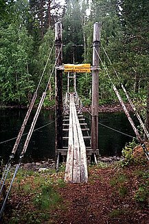
Suspension bridge over the Lögdeälven near Fredrika . |
||
| Data | ||
| location | Västerbottens län ( Sweden ) | |
| River system | Lögdeälven | |
| source | in Stöttingfjället 64 ° 34 ′ 3 ″ N , 17 ° 30 ′ 33 ″ E |
|
| Source height | approx. 500 m o.h. | |
| muzzle | at Rundvik in the Gulf of Bothnia coordinates: 63 ° 33 ′ 30 " N , 19 ° 25 ′ 42" E 63 ° 33 ′ 30 " N , 19 ° 25 ′ 42" E |
|
| Mouth height | 0 m o.h. | |
| Height difference | approx. 500 m | |
| Bottom slope | approx. 2.5 ‰ | |
| length | 200 km | |
| Catchment area | 1610 km² | |
| Drain |
MQ |
18 m³ / s |
| Flowing lakes | Lögdasjön | |
The Lögdeälven (also Lögde älv ) is an approximately 200 kilometer long river in the Swedish province of Västerbotten County .
The river is only slightly affected by humans, there are no reservoirs or hydroelectric power stations in its course, which is rare in rivers in northern Sweden. That is why it has been declared a Natura 2000 area by the Swedish government together with some tributaries .
geography
The river has its source on the Stöttingfjället , a high plateau at an altitude of 400 to 700 meters above sea level in southern Lapland . It is the watershed between the Lögdeälven and the Ångermanälven on the south side and between the Umeälven and the Öreälven in the north. The Lögdeälven river valley has many different forms of landscape. It originated after the last glacial period , the Vistula glacial period . The gorge in which the river flows is up to 60 meters deep, but over long stretches the river also flows very slowly and forms oxbow lakes .
Individual evidence
- ↑ a b "Län och huvudavrinningsområden i Sverige" (Swedish; PDF; 2.5 MB)
- ↑ a b Lögdeälven in the Nationalencyklopedin (Swedish)
