Northeast Harbor
| Northeast Harbor | ||
| Geographical location | ||
|
|
||
| Coordinates | 52 ° 31 ′ S , 169 ° 13 ′ E | |
| Region ISO | NZ | |
| country | New Zealand | |
| Sea access | Pacific Ocean | |
| Data on the natural harbor | ||
| Port entrance | 560 m wide | |
| length | around 3.6 km | |
| width | Max. 0.58 km | |
| Coastline | around 9.3 km | |
| Water depth | Max. 31 m | |
| Water depth | 17 m on average | |
| Tributaries | Northeast Stream | |
| Photography of the natural harbor | ||
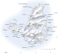
 Map of Campbell Island with Northeast Harbor protruding from the east coast into the island |
||
Northeast Harbor is a natural harbor on the sub-Antarctic Campbell Island in the southern Pacific Ocean . The island is one of the offshore islands of New Zealand .
geography
The Northeast Harbor starts on the east side of Campbell Iceland and extends 3.6 kilometers deep into the interior of the island inside. The entrance to the natural harbor extends over a width of 560 m, while the water inside the island has a maximum width of 580 m, but is mostly between 400 m and 500 m wide. The coastline measures around 9.3 km and the maximum depth of the natural harbor is 31 m. At its western end, Northeast Harbor forks into three different inlets between 140 m and 460 m long.
The mountains surrounding Northeast Harbor rise to a height of 289 m . The only tributary to the natural harbor is the 4.4 km long Northeast Stream , which rises on the western flank of the 472 m high Mount Fizeau .
Directly 400 m in front of the entrance to Northeast Harbor is the 180 m long and up to 50 m wide island of Cossack Rock . It is the only island on the east and north side of Campbell Island apart from two rocks jutting out of the sea further south .
geology
The landscape of the island created by a volcano was formed by the formation of glaciers and the two natural harbors Northeast Harbor and Perseverance Harbor , like a fjord , were formed by the movement of glaciers.
See also
literature
- Gordon S. Maxwell : Subantarctic Campbell Island . In: Tane . Vol. 16 , 1970, pp. 5–19 (English, online [PDF; 3.4 MB ; accessed on June 11, 2018]).
- Marine Protection for the New Zealand Subantarctic Islands . Department of Conservation (DOC), Wellington 2006, ISBN 0-478-14092-4 (English, online [PDF; 2.5 MB ; accessed on June 11, 2018]).
Web links
- Campbell Island . (JPG 4.0 MB)Land Information New Zealand,accessed on June 11, 2018(English, detailed topographic map ofCampbell Islandwith its small neighboring islands and rocky islands).
Individual evidence
- ↑ Coordinates and longitudes were partly made using Google Earth Version 7.3.1.4507 on June 11, 2018.
- ^ DOC: Marine Protection for the New Zealand Subantarctic Islands . 2006, p. 33 .
- ↑ a b c Campbell Island . (JPG 4.0 MB) Land Information New Zealand , accessed on June 11, 2018 (English, detailed topographic map of Campbell Island with its small neighboring islands and rocky islands).
- ^ Maxwell : Subantarctic Campbell Island . 1970, p. 6 .
