Perseverance Harbor
| Perseverance Harbor | ||
| Geographical location | ||
|
|
||
| Coordinates | 52 ° 33 ' S , 169 ° 12' E | |
| Region ISO | NZ | |
| country | New Zealand | |
| Sea access | Pacific Ocean | |
| Data on the natural harbor | ||
| Port entrance | 1 800 m wide | |
| length | around 9.1 km | |
| width | Max. 1.5 km | |
| Coastline | around 23 km | |
| Water depth | Max. 44 m | |
| Water depth | 27 m on average | |
| places | Weather station | |
| Tributaries | various small streams (brooks) | |
| Jetty | at the weather station at Beeman Point | |
| Photography of the natural harbor | ||
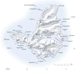
 Map of Campbell Island with Perseverance Harbor protruding from the east coast into the center of the island |
||
Perseverance Harbor is a natural harbor on the sub-Antarctic Campbell Island in the southern Pacific Ocean . The island is one of the offshore islands of New Zealand .
geography
The Perseverance Harbor starts on the east side of Campbell Iceland and extends 9.1 km in length deep into the interior of the island inside. The entrance to the natural harbor extends over a width of 1.8 km, while the water inside the island has a maximum width of 1.5 km. The coastline measures around 23 km and the maximum depth of the natural harbor is 44 m. At its western end, Perseverance Harbor divides into three different inlets, called Tucker Cove , Camp Cove and Garden Cove .
Mount Honey rises south of Perseverance Harbor , at 558 m the highest mountain on the island. From there a small stream flows directly north over Honey Falls into Perseverance Harbor . On the north side of the natural harbor rises the 420 m high Mount Lyall and towards the port entrance the 246 m high Moubray Hill .
geology
The landscape of the island created by a volcano was formed by the formation of glaciers and the two natural harbors Perseverance Harbor and Northeast Harbor , like a fjord , were formed by the movement of glaciers.
history
On January 4th, 1810, the captain Frederick Hasselburg discovered Campbell Island and the natural harbor with his brig Perseverance , where he deposited seven of his crew on the island for the seal hunt. He named the island after his employer Campbell & Co. from Sydney . After his discovery of Macquarie Island , he returned in late October of that year to take his people back in. A few days later, Hasselburg drowned under unknown circumstances. 19 years later, the Perseverance was damaged on another visit to Campbell Island off the coast. The brig's sinking, dated September 1828, was the only ship sinking off Campbell Island . After the ship sank, the natural harbor was named after the Perseverance .
During the Second World War , in March 1941, the Royal New Zealand Navy sent eleven men with ready-made coastal guard stations and provisions to the Auckland Islands and Campbell Island for three years to identify and report enemy ship activity. One of these stations was built on the coast of Perseverance Harbor . After the war ended, meteorologists used the station to observe and record the weather. In 1957 a new weather station was built below the 187 m high Beeman Hill at the so-called Beeman Point and automated in 1995.
See also
literature
- Gordon S. Maxwell : Subantarctic Campbell Island . In: Tane . Vol. 16 , 1970, pp. 5–19 (English, online [PDF; 3.4 MB ; accessed on June 10, 2018]).
- Marine Protection for the New Zealand Subantarctic Islands . Department of Conservation (DOC), Wellington 2006, ISBN 0-478-14092-4 (English, online [PDF; 2.5 MB ; accessed on June 10, 2018]).
Web links
- Campbell Island . (JPG 4.0 MB)Land Information New Zealand,accessed on June 10, 2018(English, detailed topographic map ofCampbell Islandwith its small neighboring islands and rocky islands).
Individual evidence
- ↑ Coordinates and longitudes were partly made using Google Earth Version 7.3.1.4507 on June 10, 2018.
- ^ DOC: Marine Protection for the New Zealand Subantarctic Islands . 2006, p. 33 .
- ↑ a b Campbell Island . (JPG 4.0 MB) Land Information New Zealand , accessed on June 10, 2018 (English, detailed topographic map of Campbell Island with its small neighboring islands and rocky islands).
- ^ Maxwell : Subantarctic Campbell Island . 1970, p. 6 .
- ^ Jock Phillips : Subantarctic islands - Early human settlement . In: Te Ara - the Encyclopedia of New Zealand . Ministry for Culture & Heritage , September 12, 2012, accessed June 10, 2018 .
- ^ Jock Phillips : Subantarctic islands - Second World War and after . In: Te Ara - the Encyclopedia of New Zealand . Ministry for Culture & Heritage , September 12, 2012, accessed June 10, 2018 .
- ^ DOC: Marine Protection for the New Zealand Subantarctic Islands . 2006, p. 25 .
