
Nuraghe Cuccureddus
| Nuraghe Cuccureddus | |||
|---|---|---|---|
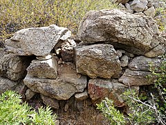
 Northwest side of the main tower |
|||
Location in Sardinia |
|||
| Coordinates | 39 ° 8 '10.8 " N , 9 ° 29' 49.4" E | ||
| place | Villasimius , Sardinia , Italy | ||
| Emergence | 1600–600 BC Chr. | ||
| height | 73 m | ||

The Nuraghe Cuccureddus (also Nuraghe Cuccureddus I ) is a nuraghe near the south coast of the Italian island of Sardinia . It is located northwest of the Campulongu settlement in the municipality of Villasimius in the Sud Sardegna province . The building is assigned to the nuragic culture.
location
The Nuraghe Cuccureddus is located on the top of a 73 meter high hill above the Via delle Aquile about 700 meters northwest of the Campulongu settlement. The coast of the southwestern Mediterranean Sea at Spiaggia Cuccureddus beach is 380 meters away. To the northwest of the beach there is another nuraghe called Nuraghe arcaico Cuccureddus or Nuraghe Cuccureddus II . This is located 90 meters from the coast on a promontory and is about 440 meters away from the Nuraghe Cuccureddus I. About 260 meters north of the Nuraghe Cuccureddus I , the Riu Foxi irrigates the Piana di Santa Maria plain before it flows into the sea at the Spiaggia di Campus beach in the west. The center of the parish of Villasimius is 2.1 kilometers to the east.
description

The nuraghe complex was built in a strategically favorable location. It stands on the easternmost and highest hill of the small range of hills Cuccureddus , which stretches from the coast from west to east. From here it was possible to overlook the bay of the Golfo di Carbonara and secure the plain of Santa Maria in the north, including the mouth of the Riu Foxi in the west. It is possible that the Nuraghe Cuccureddus formed a common control system with the Nuraghe Guardone and the Pseudonuraghe Cixilianu .

The Nuraghe Cuccureddus consists of the remains of a main tower with a western extension. Both structures have a circular ground plan and, like all nuraghi, are erected from large, uncut stone blocks without mortar, similar to dry stone masonry .
The outer wall of the main tower with a diameter of about 9 meters tapers conically upwards. The northwest side of the tower is best preserved. Of the extension with an outer diameter of around 6 meters, only the lower two or three stone layers remain. Both structures are overgrown by vegetation, the interiors are filled with bushes.
End of the 7th century BC BC the Phoenicians founded a settlement on the west side of Cuccureddus facing the coast , the Insediamento Fenicio di Cuccureddus , of which the remains of the foundation walls of an Aštart sanctuary can still be seen on the western hill. The use of the Nuraghe Cuccureddus in the following period has not been clarified.
- Views of the nuraghe

West side of the nuraghe
Cultivation

Main tower

Eastern outer wall


See also
Individual evidence
- ↑ L'insediamento di Cuccureddus. (No longer available online.) La mia Sardegna, archived from the original on November 7, 2017 ; Retrieved November 5, 2017 (Italian).
- ↑ Silvano Vinceti: Area marina protetta di Capo Carbonara . Armando, Rome 2008, ISBN 978-88-6081-142-4 , Nuraghe Cuccureddus, p. 58–59 (Italian, digitized [accessed November 5, 2017]).
- ↑ Villasimius Porto di fenicio Cuccureddus. Regione Autonoma della Sardegna, 2017, accessed November 5, 2017 (Italian).