Nyanga (river)
| Nyanga | ||
|
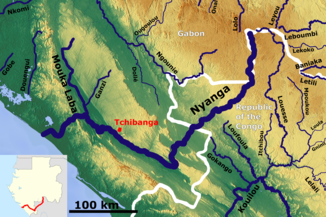
The course of the Nyanga |
||
| Data | ||
| location |
|
|
| River system | Nyanga | |
| source | in the Birougou Mountains | |
| Source height | about 900 m | |
| muzzle | 70 km north of Mayumba in the Atlantic Coordinates: 2 ° 58 ′ 45 ″ S , 10 ° 16 ′ 15 ″ O 2 ° 58 ′ 45 ″ S , 10 ° 16 ′ 15 ″ E |
|
| Mouth height | 0 m | |
| Height difference | about 900 m | |
| Bottom slope | about 1.5 ‰ | |
| length | about 600 km | |
| Catchment area | 22,500 km² | |
| Discharge at the Tchibanga A Eo gauge : 12,400 km² |
MNQ MQ Mq MHQ |
87.3 m³ / s 331 m³ / s 26.7 l / (s km²) 497 m³ / s |
| Right tributaries | Moukalaba | |
The Nyanga is a river in Gabon and the Republic of the Congo .
course
It rises at about 900 meters in the Birougou Mountains and has a length of 600 km. It flows into the Atlantic about 70 km north of Mayumba. About 80% of its catchment area of 22,500 km² is on Gabonese territory.
Hydrology
The flow rate of the river was measured in Tchibanga . The annual average was 331 m³ / s.

