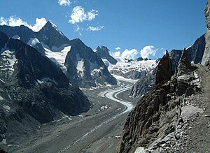
Oberaletsch Glacier
| Oberaletsch Glacier | ||
|---|---|---|
|
Oberaletsch Glacier with Nesthorn (left) |
||
| location | Canton of Valais , Switzerland | |
| Mountains | Bernese Alps | |
| Type | Valley glacier | |
| length | 8.8 km (2007) | |
| surface | 23.66 km² (1993) | |
| Exposure | Southeast | |
| Altitude range | 3890 m above sea level M. - 2144 m above sea level M. (2001) | |
| Tilt | ⌀ 21.5 ° (39%) | |
| Ice volume | 2.21 ± 0.55 km³ (1993) | |
| Coordinates | 640.85 thousand / 141099 | |
|
|
||
| drainage | Massa , Rhone | |
The Oberaletsch Glacier is a valley glacier on the south side of the Bernese Alps , in the canton of Valais , in Switzerland . In 2007 the length was determined to be 8.8 km, in the following years the change in length could not be reliably determined due to the high debris cover. For 1993 the area is given as 23.66 km².
location
The Oberaletsch Glacier consists of two spring glaciers of roughly the same size . The actual Oberaletsch glacier starts as a steep slope glacier on the southwest flank of the Aletschhorn at around 3700 m above sea level. In the valley it joins the ice masses of other firn fields and then flows south, flanked by the Schinhorn in the west and the Geisshorn in the east. The second source glacier is the Beichgletscher , which arises on the eastern slope of the glaciated Lötschentaler Breithorn at around 3700 m and flows with slight turns to the east, bordered by the Nesthorn in the south and the Schinhorn in the north. From the union point, the upper Aletsch glacier turns to the southeast and flows through the deep valley between the Sparrhorn ( 3021 m above sea level. M. ) and the Great Fusshorn ( 3627 m above sea level. M. ). In the lower section the glacier is heavily covered with rubble. The glacier tongue ends in a gorge at around 2150 m above sea level. M. The meltwater flows to the Massa , the outflow of the Great Aletsch Glacier, and with this to the Rhone .
During the high stage of the Little Ice Age around the middle of the 19th century, the Oberaletsch Glacier was connected to the Great Aletsch Glacier by the ice-filled Oberaletsch Gorge. This connection broke off around 1878. Another, flat tongue flap reached over a ridge to the Obflühgand until 1906 .
Oberaletschhütte
The Oberaletschhütte of the Swiss Alpine Club at 2,640 m above the confluence of the Beich and Oberaletsch glaciers was originally only accessible via the glacier. A new panorama path has existed since July 2005, which leads past the southwest flank of the Fusshörner and enables a glacier-free approach. The hut can be reached this way in around 4 to 5 hours from the Belalp mountain station.
The area of the Oberaletsch Glacier, together with the Great Aletsch Glacier, was included in the UNESCO World Natural Heritage as the Jungfrau-Aletsch-Bietschhorn Biosphere Reserve in December 2001 .
Individual evidence
- ↑ a b Research Institute for Hydraulic Engineering, Hydrology and Glaciology (VAW) of the ETH Zurich (Ed.): Oberaletschgletscher. In: Swiss Glacier Measurement Network. ( ethz.ch , also as PDF , accessed on February 13, 2014).
- ↑ a b c Daniel Farinotti, Matthias Huss, Andreas Bauder, Martin Funk: An estimate of the glacier ice volume in the Swiss Alps. In: Global and Planetary Change. 68: 225-231, 2009 ( online ; PDF; 756 kB).
- ^ WGMS: Fluctuations of Glaciers Database. World Glacier Monitoring Service, Zurich 2013 ( DOI: 10.5904 / wgms-fog-2013-11 ), accessed on December 11, 2013
- ↑ Andreas Linsbauer, Frank Paul, Wilfried Haeberli: Modeling glacier thickness distribution and bed topography over entire mountain ranges with GlabTop: Application of a fast and robust approach. In: Journal of Geophysical Research. , Volume 117, F03007, 2012, doi : 10.1029 / 2011JF002313 ( online )
Web links
- Map section at map.geo.admin.ch
- Oberaletsch Glacier online on Glaciers
- Change in length of the Oberaletsch glacier since 1870 (PDF file; 110 kB)
- Oberaletschhütte SAC

