Upper Bienert Park

A park on the Hohen Stein in the Dresden district of Plauen , above the Plauen reason , is referred to as the Oberer Bienertpark (recently in municipal publications Alter Bienertpark ) .
prehistory

On January 1, 1903, Plauen was incorporated into Dresden and the fire brigade in Dresden was now responsible for fire extinguishing in the Bienertmühle - in addition to the plant fire brigade . In the course of improving fire protection and due to the fact that the current part of the city no longer had its own fire station , a sprinkler system had to be installed in the mill . In order to provide the necessary amount of water and the required pressure, a fire water pond was created near the Hohe Steins . This gave the already very socially committed brothers Theodor and Erwin Bienert, the sons of Gottlieb Traugott Bienert and, after his death, the owners of the Bienertmühle, with the idea of creating a replacement for the areas now occupied by industry in the lower area of Plauen and for the Plauen citizens To "give back part of the natural area that was more and more lost during the industrialization in Plauenschen Grund": One of the earliest known ecological compensation measures took place in this area through Bienert's commitment and financed by Erwin Bienert. But it was also part of Bienert's commitment to beautifying Plauen's landscape as a whole.
execution
Erwin Bienert provided 80,000 square meters of land to implement this idea. i. the entire area between today's Dresden-Plauen grammar school and the Hohen Stein, was available free of charge and covered the entire cost with 30,000 Reichsmarks . Originally villas were to be built on this area, a large part of the area had already been terraced (this terracing can still be seen today, the observatory and sports field of the grammar school are located on such terraces) and an access road from Coschützer Straße was already there been carried out in the approach.
The garden architect Max Bertram provided the design for the "Bienertpark" in 1906, which was carried out that same year. It was later referred to as the "Upper Bienert Park" because Bertram submitted the planning for the "Lower Bienert Park", later known as the " Dölzschener Bienert Park ", which in turn was financed by Erwin's brother Theodor, in the same year .
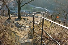
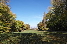
Special elements of the "Upper Bienert Park" are the now renatured fire extinguishing pond, which was created as an artificial lake and the creation of the lookout point of the "Forsthausbastion" above the forester's house on the Hegereiterbrücke, which was demolished in 1965 . Another part of Bertram's planning was to keep the central area free from any vegetation (there are around 1200 trees and bushes in the western part). The view from the Hohe Stein over Löbtau and the Elbe to the Lößnitz slopes, often also called "Bienertwiese", was part of his conception.
It is estimated that Bertram has created a work "that seems to be almost embedded in the natural conditions" and, despite his artistic demands, created a natural space with spatial structures, visual relationships and pathways.
Rehabilitation and renaturation
The area was preserved after 1945 with minimal effort, especially since the fire extinguishing pond was used for the Bienertmühle until the 1990s. After it was shut down as a mill, as it was no longer maintained, it became increasingly dangerous: After several attempts and rescheduling, it was redesigned and restructured, like the entire other area. This was done taking into account that the eastern part of the Bertram park concept was given up in GDR times in favor of school use. Nevertheless, its concept only became clear again during the renovation and renaturation in 2006 from ERDF funds: Now it is again a place of rest and relaxation, without games. Except in winter: The meadow slope planned by Bertram in the middle part with its (taken over) terraces are ideal toboggan slopes for families in winter and when there is snow.
Web links
literature
- Municipal parks - Alter Bienertpark. Flyer of the state capital Dresden (July 2008), also available online.
Individual evidence
- ↑ Jürgen Riess: The Bienertweg in Plauenschen Grund - a hiking and nature guide through a unique natural and industrial landscape . Association for scientists and engineering staff Dresden e. V. (WIMAD) (Ed.) (= Dresdner Impressionen, Vol. 2). 2nd, revised edition, Dresden 2013. Without ISBN, p. 53.
- ^ A b State capital Dresden (ed.): Municipal parks - Alter Bienertpark . Flyer of the state capital Dresden (July 2008), also available online
- ↑ Paul Dittrich: Between Hofmühle and Heidenschanze - History of the Dresden suburbs Plauen and Coschütz. 2nd, revised edition. Adolf Urban, Dresden 1941, p. 177.
- ↑ dresden.de: Signs for the Weißeritzgrünzug ( memento from April 19, 2014 in the Internet Archive ) (PDF; 4.8 MB), there Info Point 15, accessed from the web archive on April 14, 2020.
- ↑ dresden.de: Signs for the Weißeritzgrünzug ( memento from April 19, 2014 in the Internet Archive ) (PDF; 4.8 MB), there Info Point 15, accessed from the web archive on April 14, 2020.
Coordinates: 51 ° 1 ′ 31.1 ″ N , 13 ° 42 ′ 12 ″ E


